
xroute


calculateRouteInfo
Calculates travel time and distance information for the given route. Described by stations using the given routing parameters respecting the specified exceptionPaths.
When all stations are identical, just cost, distance and time will be set to "0".
| Parameter Name | Type | Description |
|---|---|---|
waypoints
|
WaypointDesc[]
|
The waypoints of the route. The first waypoint specifies the start, the last waypoint specifies the destination. The waypoints in between specify the via-stations. |
options
|
RoutingOption[]
|
The routing option to respect when calculating this route. |
exceptionPaths
|
ExceptionPath[]
|
The exception paths to respect when calculating this route (for example to calculate alternative routes). |
| Return Type | Description |
|---|---|
RouteInfo
|
A summary of information for this route. |
XRouteException
|
Thrown if an xRoute server exception such as an invalid request parameter occurs. |
XServiceException
|
Thrown if a PTV xServer framework exception occurs. |
calculateRoute
Calculates the detailed route for the given stations. Uses the specified routing options, respecting the defined exceptionPaths.
When all stations are identical, just cost, distance and time will be set to "0".
| Parameter Name | Type | Description |
|---|---|---|
waypoints
|
WaypointDesc[]
|
The first waypoint specifies the start, the last waypoint specifies the destination. The waypoints in between specify the via-stations. |
options
|
RoutingOption[]
|
The routing option to respect when calculating this route. |
exceptionPaths
|
ExceptionPath[]
|
The exception paths to respect when calculating this route (for example to calculate alternative routes). |
details
|
ResultListOptions
|
The detail of the requested route (not all combinations make sense, see ResultListOptions). |
| Return Type | Description |
|---|---|
Route
|
Returns the detailed route description. |
XRouteException
|
Thrown if an xRoute server exception such as an invalid request parameter occurs. |
XServiceException
|
Thrown if a PTV xServer framework exception occurs. |
calculateExtendedRoute
Calculates the detailed route for the given stations. Uses the specified routing options, respecting the defined exceptionPaths.
When all stations are identical, just route.info.cost, route.info.distance and route.info.time will be set to "0".
| Parameter Name | Type | Description |
|---|---|---|
waypoints
|
WaypointDesc[]
|
The first waypoint specifies the start, the last waypoint specifies the destination. The waypoints in between specify the via-stations. |
options
|
RoutingOption[]
|
The routing option to respect when calculating this route. |
exceptionPaths
|
ExceptionPath[]
|
The exception paths to respect when calculating this route (for example to calculate alternative routes). |
details
|
ResultListOptions
|
The detail of the requested route (not all combinations make sense, see ResultListOptions). |
countryInfoOptions
|
CountryInfoOptions
|
The country info option to respect when calculating toll costs. |
| Return Type | Description |
|---|---|
ExtendedRoute
|
Returns the detailed route description and the country info including toll informations. |
XRouteException
|
Thrown if an xRoute server exception such as an invalid request parameter occurs. |
XServiceException
|
Thrown if a PTV xServer framework exception occurs. |
calculateMatrixInfo
Calculates all times and distances from each start location to all destinations (NxM Routing) using the specified RoutingOptions and MatrixOptions options. Restrictions: This service method does not support WaypointDesc with routing or vehicle options and it does not support via types. This service method does support dynamic routing, exception paths and traffic information using the geodatasource layer. But as these features use time-dependent data, the results are all valid only for the given start time of the route and should not be used for tour planning.
The matrix should not be larger than 750x750 waypoints, otherwise PTV xRoute Server might run out of memory.
Consider restricting the search space for matrix calculation using the RoutingParameter ROUTING_RECTANGLE.
| Parameter Name | Type | Description |
|---|---|---|
startwaypoints
|
WaypointDesc[]
|
The start waypoints for all start locations of the matrix request. |
destwaypoints
|
WaypointDesc[]
|
The destination waypoints for all destination locations of the matrix request. |
options
|
RoutingOption[]
|
The routing option to respect when calculating this matrix. |
matrixOptions
|
MatrixOptions
|
The matrix option to respect when calculating this matrix. |
| Return Type | Description |
|---|---|
MatrixInfo
|
Returns the matrix of RouteInfo elements. |
XRouteException
|
Thrown if an xRoute server exception such as an invalid request parameter occurs. |
XServiceException
|
Thrown if a PTV xServer framework exception occurs. |
startCalculateMatrixInfo
| Parameter Name | Type | Description |
|---|---|---|
startwaypoints
|
WaypointDesc[]
|
The start waypoints for all start locations of the matrix request. |
destwaypoints
|
WaypointDesc[]
|
The destination waypoints for all destination locations of the matrix request. |
options
|
RoutingOption[]
|
The routing option to respect when calculating this matrix. |
matrixOptions
|
MatrixOptions
|
The matrix option to respect when calculating this matrix. |
| Return Type | Description |
|---|---|
Job
|
The Job reference. |
XRouteException
|
Thrown if an xRoute server exception such as an invalid request parameter occurs. |
XServiceException
|
Thrown if a PTV xServer framework exception occurs. |
fetchMatrixInfo
| Parameter Name | Type | Description |
|---|---|---|
id
|
String
|
The id of the job. |
| Return Type | Description |
|---|---|
MatrixInfo
|
Returns the matrix of RouteInfo elements. |
XRouteException
|
Thrown if an xRoute server exception such as an invalid request parameter occurs. |
XServiceException
|
Thrown if a PTV xServer framework exception occurs. |
calculateReachableObjects
Calculates the reachability starting from either a certain sink or a route for a set of given locations. The functions return for each location if it can be reached in a certain time or distance domain respecting the given routing options. Restrictions: This service method does not support WaypointDesc with routing or vehicle options and it does not support via types.
| Parameter Name | Type | Description |
|---|---|---|
sink
|
WaypointDesc
|
The sink from which the reachability is calculated. |
binaryPathDesc
|
String
|
The binary representation of the route from which reachability is calculated (see Route-Object). |
locations
|
WaypointDesc[]
|
The locations which should be reached in a certain time or distance domain. |
options
|
RoutingOption[]
|
The routing option to respect when calculating this matrix. |
expansionDesc
|
ExpansionDescription
|
The description of the horizon and type of expansion. Restrictions: For the horizon only one description is allowed. |
| Return Type | Description |
|---|---|
Reach
|
Returns the ReachInfo for each location which should be reached. The array index corresponds to the locations array index. |
XRouteException
|
Thrown if an xRoute server exception such as an invalid request parameter occurs. |
XServiceException
|
Thrown if a PTV xServer framework exception occurs. |
calculateIsochrones
Calculates one or more isochrones (time or distance domain) starting from a certain location called sink. The result is given either as surrounding polygons for the certain isochrone horizons respecting the given routing options or as a set of segments covered for each horizon (see figure). Restrictions: This service method does not support WaypointDesc with routing or vehicle options and it does not support via types.
| Parameter Name | Type | Description |
|---|---|---|
sink
|
WaypointDesc
|
The sink from which the reachability is calculated. |
options
|
RoutingOption[]
|
The routing option to respect when calculating this matrix. |
isoOptions
|
IsochroneOptions
|
The isochrone options to respect when calculating the isochrone. |
| Return Type | Description |
|---|---|
Isochrone
|
Returns the IsochroneInfo for each horizon. The array index corresponds to the horizon index in the isoOptions object. |
XRouteException
|
Thrown if an xRoute server exception such as an invalid request parameter occurs. |
XServiceException
|
Thrown if a PTV xServer framework exception occurs. |
calculateTour
DEPRECATED: Please use calculateAdvancedTour instead. Calculates a tour considering break and rest rules (defined by the profile element BreakAndRestRules). All arrival times at stations and segments will be extended by break, rest, waiting times and so on. Restrictions: A tour point must not use fuzzy linking or combined transports. The routing option IS_DESTTIME must be false. Dynamic routing must also be disabled.
| Parameter Name | Type | Description |
|---|---|---|
waypoints
|
WaypointDesc[]
|
The first waypoint specifies the start, the last waypoint specifies the destination. The waypoints in between specify the via-stations. At least the first and the last station must be of type TourPointDesc. The order of all tour points will not be changed, use PTV xTour Server for optimization problems like this. |
options
|
RoutingOption[]
|
The routing option to respect when calculating this route. |
exceptionPaths
|
ExceptionPath[]
|
The exception paths to respect when calculating this route (for example to calculate alternative routes). |
details
|
ResultListOptions
|
The detail of the requested route (not all combinations make sense, see ResultListOptions). |
countryInfoOptions
|
CountryInfoOptions
|
The country info option to respect when calculating toll costs. |
| Return Type | Description |
|---|---|
Tour
|
Returns the detailed route, tour descriptions and the country info including toll informations. |
XRouteException
|
Thrown if an xRoute server exception such as an invalid request parameter occurs. |
XServiceException
|
Thrown if a PTV xServer framework exception occurs. |
calculateAdvancedTour
Calculates a tour considering complex break and rest rules. In order to distinguish it from calculateTour(), it implements all current EU regulations and provides better results. The break and rest rules are defined in DriverRegulations, but not by the profile element BreakAndRestRules. Restrictions: A tour point must not use fuzzy linking or combined transports. The routing option IS_DESTTIME must be false. Dynamic routing must also be disabled.
| Parameter Name | Type | Description |
|---|---|---|
waypoints
|
WaypointDesc[]
|
The waypoints of the route. The first waypoint specifies the start, the last waypoint specifies the destination. The waypoints in between specify the via-stations. At least the first and the last station must be of type TourPointDesc. The order of all tour points will not be changed, use PTV xTour Server for optimization problems like this. |
tourOptions
|
TourOptions
|
The time profile options to respect when calculating this tour. |
routingOptions
|
RoutingOption[]
|
The routing option to respect when calculating this tour. |
exceptionPaths
|
ExceptionPath[]
|
The exception paths to respect when calculating this route (for example to calculate alternative routes). |
details
|
ResultListOptions
|
The detail of the requested route (not all combinations make sense, see ResultListOptions). |
countryInfoOptions
|
CountryInfoOptions
|
The country info option to respect when calculating toll costs. |
| Return Type | Description |
|---|---|
AdvancedTour
|
Returns the detailed route and tour descriptions and the country info including toll informations. |
XRouteException
|
Thrown if an xRoute server exception such as an invalid request parameter occurs. |
XServiceException
|
Thrown if a PTV xServer framework exception occurs. |
searchForReachableObjects
Searches all objects which are reachable, starting from either a certain sink or along a route. Restrictions: This service method does not support WaypointDesc with routing or vehicle options and it does not support via types.
| Parameter Name | Type | Description |
|---|---|---|
sink
|
WaypointDesc
|
The sink from which the reachability is calculated. |
binaryPathDesc
|
String
|
The binary representation of the route (see Route-Object) from which reachability is calculated. |
options
|
RoutingOption[]
|
The routing option to respect when calculating the reachability. |
reachableObjectOptions
|
ReachableObjectsOptions
|
The options for calculating the reachable objects. |
exceptionPaths
|
ExceptionPath[]
|
Not used for now. The exception paths to respect when calculating the reachability. |
| Return Type | Description |
|---|---|
ReachableObjects
|
Returns the reachability and more for each object which can be reached. |
XRouteException
|
Thrown if an xRoute server exception such as an invalid request parameter occurs. |
XServiceException
|
Thrown if a PTV xServer framework exception occurs. |
calculateBulkRouteInfo
Calculates travel time and distance information for the given routes. The routes will all be calculated using the specified routing parameters respecting the defined exceptionPaths.
When all stations are identical, just cost, distance and time will be set to "0".
The number of routes should not be greater than 20000, otherwise PTV xRoute Server might run out of memory.
| Parameter Name | Type | Description |
|---|---|---|
waypoints
|
WaypointDesc[][]
|
An array of waypoint arrays, each of which representing a route. |
options
|
RoutingOption[]
|
The routing option to respect when calculating these routes. |
exceptionPaths
|
ExceptionPath[]
|
The exception paths to respect when calculating these routes (for example to calculate alternative routes). |
| Return Type | Description |
|---|---|
BulkRouteInfo
|
The summary information for the given routes. |
XRouteException
|
Thrown if an xRoute server exception such as an invalid request parameter occurs. |
XServiceException
|
Thrown if a PTV xServer framework exception occurs. |
startCalculateBulkRouteInfo
| Parameter Name | Type | Description |
|---|---|---|
waypoints
|
WaypointDesc[][]
|
An array of waypoint arrays, each of which representing a route. |
options
|
RoutingOption[]
|
The routing option to respect when calculating these routes. |
exceptionPaths
|
ExceptionPath[]
|
The exception paths to respect when calculating these routes (for example to calculate alternative routes). |
| Return Type | Description |
|---|---|
Job
|
The Job reference. |
XRouteException
|
Thrown if an xRoute server exception such as an invalid request parameter occurs. |
XServiceException
|
Thrown if a PTV xServer framework exception occurs. |
fetchBulkRouteInfo
| Parameter Name | Type | Description |
|---|---|---|
id
|
String
|
The id of the job. |
| Return Type | Description |
|---|---|
BulkRouteInfo
|
The summary information for the given routes. |
XRouteException
|
Thrown if an xRoute server exception such as an invalid request parameter occurs. |
XServiceException
|
Thrown if a PTV xServer framework exception occurs. |
watchJob
| Parameter Name | Type | Description |
|---|---|---|
id
|
String
|
The id of the job. |
watchOptions
|
WatchOptions
|
The options to control job status and progress updates. |
| Return Type | Description |
|---|---|
Job
|
The job reference. |
SystemException
|
Thrown if job management is not available, for example if it is misconfigured. |
stopJob
| Parameter Name | Type | Description |
|---|---|---|
id
|
String
|
The id of the job to be stopped. |
| Return Type | Description |
|---|---|
Job
|
The job reference. |
SystemException
|
Thrown if a preliminary result cannot be provided or job management in general is not available, for example if it is misconfigured. |
deleteJob
| Parameter Name | Type | Description |
|---|---|---|
id
|
String
|
The id of the job to be deleteed. |
| Return Type | Description |
|---|---|
Job
|
The job reference. |
SystemException
|
Thrown if job management is not available, for example if it is misconfigured. |
AdvancedTour
Extends ExtendedRoute
| Attribute Name | Type | Description |
|---|---|---|
tourPointResults
|
TourPointResult[]
|
An array of TourPointsResults that contains details about each tour point. The same index as in the request should be used. |
tourEvents
|
TourEvent[]
|
The time profile in details as an array of events (can be empty with the tour still being valid). |
isViolated
|
boolean
|
If true, a violation occurs. If false, the calculate time profile is valid. |
startTime
|
Calendar
|
Specifies the beginning of the calculated tour. |
tourPeriod
|
int
|
Overall duration of the time profile including all idle, driving and service events. |
remainingPeriods
|
String
|
Updated remaining periods. |
defermentPotential
|
int
|
Period of time the complete result can be deferred without changing the structure of the result. |
genuineWaitingPeriod
|
int
|
Summary of all genuine waiting periods at the tour points in this tour. |
recreationPeriods
|
RecreationPeriods
|
Summary of all recreation periods in this tour. |
AustraliaNGA2011
Extends CENEmissions
| Attribute Name | Type | Description |
|---|---|---|
energyUseTank2Wheel
|
double
|
The energy use tank-to-wheel in [MJ]. |
co2eWell2Tank
|
Double
|
The CO2e well-to-tank in [kg]. This value is only present for conventional fuels with a bio fuel ratio of 0%. |
co2eTank2Wheel
|
double
|
The CO2e tank-to-wheel in [kg]. |
co2Tank2Wheel
|
double
|
The CO2 tank-to-wheel in [kg]. |
ch4Tank2Wheel
|
double
|
The CH4 (methane) tank-to-wheel in [g]. |
n2oTank2Wheel
|
double
|
The N2O (Nitrous oxide) tank-to-wheel in [g]. |
fuelConsumption
|
double
|
The fuel consumption in [kg]. This value is 0 for vehicle specific conversion factors. |
AustraliaNGA2015
Extends CENEmissions
| Attribute Name | Type | Description |
|---|---|---|
energyUseTank2Wheel
|
double
|
The energy use tank-to-wheel in [MJ]. |
co2eWell2Tank
|
Double
|
The CO2e well-to-tank in [kg]. This value is only present for conventional fuels with a bio fuel ratio of 0%. |
co2eTank2Wheel
|
double
|
The CO2e tank-to-wheel in [kg]. |
co2Tank2Wheel
|
double
|
The CO2 tank-to-wheel in [kg]. |
ch4Tank2Wheel
|
double
|
The CH4 (methane) tank-to-wheel in [g]. |
n2oTank2Wheel
|
double
|
The N2O (Nitrous oxide) tank-to-wheel in [g]. |
fuelConsumption
|
double
|
The fuel consumption in [kg]. This value is 0 for vehicle specific conversion factors. |
BoundingRectangle
A bounding rectangle specified by its right top and left bottom coordinates.
| Attribute Name | Type | Description |
|---|---|---|
leftBottom
|
Point
|
The left bottom corner of the rectangle. The coordinates are given in the same format as specified in the request. |
rightTop
|
Point
|
The right top corner of the rectangle. The coordinates are given in the same format as specified in the request. |
BreakIntervals
| Attribute Name | Type | Description |
|---|---|---|
breakPeriod
|
int
|
Specifies the duration of the break. |
intervals
|
Interval[]
|
Specifies intervals in which breaks are stipulated. |
BreakRule
| Attribute Name | Type | Description |
|---|---|---|
drivingPeriod
|
int
|
Uninterrupted period of time a driver is allowed to drive without a break. Remark: According to EU regulation : 4h 30min (16200s) |
breakPeriod1
|
int
|
Minimum period of time required for the first break. Remark: According to EU regulation : 15min (900s) |
breakPeriod2
|
int
|
Minimum period of time required for the second break. Remark: According to EU regulation : 30min (1800s) |
BreakRuleAUS
After a driving period a driver shall take an uninterrupted break of at least the break period.
The Australian Heavy Vehicle Driver Fatigue Legislation sets out minimum rest and maximum work hours. In case of the BreakRuleAUS the maximum work hours are equal to the maximum observation period minus the break period.
| Attribute Name | Type | Description |
|---|---|---|
breakPeriod
|
int
|
Minimum duration of a required rest break. Remark: According to NTC_AUS regulation: 15m (900s) |
observationPeriodForOneBreak
|
int
|
The observation period in which at least one rest break must be done. Remark: According to NTC_AUS regulation: 5,25h (18900s) |
observationPeriodForTwoBreaks
|
int
|
The observation period in which at least two rest breaks must be done. Remark: According to NTC_AUS regulation: 7,5h (27000 s) |
observationPeriodForFourBreaks
|
int
|
The observation period in which at least four rest breaks must be done. Remark: According to NTC_AUS regulation: 10h (36000 s) |
BrunnelManoeuvre
An optional tunnel or bridge manoeuvre.
| Attribute Name | Type | Description |
|---|---|---|
brunnelIdx
|
int
|
The array index of the description text or road name of the tunnel or bridge. |
brunnelEndIdx
|
int
|
The index of the manoeuvre where the bridge or tunnel ends. |
brunnelDist
|
int
|
The distance from the bridge or tunnel exit to the manoeuvre in [m]. |
BulkRouteInfo
| Attribute Name | Type | Description |
|---|---|---|
bulkRouteInfoResult
|
BulkRouteInfoResult[]
|
For each input route this array contains an element at the same index containing the results of the route calculation. |
BulkRouteInfoResult
| Attribute Name | Type | Description |
|---|---|---|
routeInfo
|
RouteInfo
|
If the routing has been executed successfully, this element contains the resulting time and distance of the route. Otherwise this element is nil, and the error attributes contain information on why the routing failed. |
errorCode
|
ErrorCode
|
If the routing has been executed successfully, this is SUCCESS. Otherwise it contains the error code describing why the routing failed. |
errorDescription
|
String
|
If the routing has been executed successfully, this attribute is nil. Otherwise it contains the error message describing why the routing failed. |
CENEmissionConfiguration
| Attribute Name | Type | Description |
|---|---|---|
fleetSpecificAverageFuelConsumption
|
Double
|
The average fuel consumption for a fleet in [l/100km] for liquid fuel types or [kg/100km] for gaseous fuel types like COMPRESSED_NATURAL_GAS. |
routeSpecificAverageFuelConsumption
|
Double
|
The average fuel consumption for a specific type of route in [l/100km] for liquid fuel types or [kg/100km] for gaseous fuel types like COMPRESSED_NATURAL_GAS. |
actualFuelConsumptionForThisRoute
|
Double
|
The actual fuel consumption for this route in [l] for liquid fuel types or [kg] for gaseous fuel types like COMPRESSED_NATURAL_GAS. |
cenVersion
|
CENVersion
|
Specifies the CEN or other factor-based version for calculating the emissions. |
CENEmissionConversionFactors
| Attribute Name | Type | Description |
|---|---|---|
biofuelPercent
|
int
|
Percentage of biofuel in fuel blend. 0 means no biofuel, 100 means 100% biofuel. |
conversionFactors
|
CENEmissions
|
Holder for actual conversion factors. |
CENEmissionScenarios
| Attribute Name | Type | Description |
|---|---|---|
vehicleSpecific
|
CENEmissions
|
The emissions based on the vehicle specific fuel consumption. The fuel consumption of the vehicle is set by request or in the vehicle profile. |
fleetSpecific
|
CENEmissions
|
The emissions based on a fleet specific fuel consumption. |
routeSpecific
|
CENEmissions
|
The emissions based on a route specific fuel consumption. |
actualFuelConsumption
|
CENEmissions
|
The emissions based on the actual fuel consumption for this route. |
basedOnHBEFA
|
CENEmissions
|
The emissions based on the fuel consumption as it was calculated by HBEFA 3.1 or higher. The values based on HBEFA 2.1 will not be correct. If you do not want to calculate emissions based on HBEFA, use HBEFAVersion NO_HBEFA. |
vehicleSpecificConversionFactors
|
CENEmissionConversionFactors[]
|
The energy and emission conversion factors. If the fuel type supports blends with biofuel, three items are provided in this order (duplicates may occur if the actual fuel blend contains 0% or 100% biofuel):
Only filled if CENVersion does not equal CEN_2011. |
CENEmissions
| No attributes defined. |
CENEmissions2011
Extends CENEmissions
| Attribute Name | Type | Description |
|---|---|---|
energyUseTank2Wheel
|
double
|
The energy use tank-to-wheel in [MJ]. |
energyUseWell2Wheel
|
double
|
The energy use well-to-wheel in [MJ]. |
co2Tank2Wheel
|
double
|
The CO2e tank-to-wheel. The CO2e value is the unit for comparing the radiative forcing of a greenhouse gas to carbon dioxide according to [ISO 14064-1:2006] in [kg]. |
co2Well2Wheel
|
double
|
The CO2e well-to-wheel in [kg]. |
CENEmissions2012
Extends CENEmissions
| Attribute Name | Type | Description |
|---|---|---|
energyUseTank2Wheel
|
double
|
The energy use for tank-to-wheel calculation in [MJ]. |
energyUseWell2Wheel
|
double
|
The energy use for well-to-wheel calculation in [MJ]. |
energyUseWell2Tank
|
double
|
The energy use for well-to-tank calculation in [MJ]. |
co2eTank2Wheel
|
double
|
The CO2e tank-to-wheel calculation. The CO2e value is the unit for comparing the radiative forcing of a greenhouse gas to carbon dioxide according to [ISO 14064-1:2006] in [kg]. |
co2eWell2Wheel
|
double
|
The CO2e well-to-wheel calculation in [kg]. |
co2eWell2Tank
|
double
|
The CO2e well-to-tank calculation in [kg]. |
fuelConsumption
|
double
|
The fuel consumption in [kg]. This value is 0 for vehicle specific conversion factors. |
CO2DecreeFrance2011
Extends CENEmissions
The VehicleParameter AVERAGE_FUEL_CONSUMPTION has to be set to determine the correct vehicle class. For further information see the xRoute UseCase Emissions.
| Attribute Name | Type | Description |
|---|---|---|
co2Well2Wheel
|
double
|
The CO2 well-to-wheel value in [kg]. |
co2Well2Tank
|
double
|
The CO2 well-to-tank value in [kg]. |
CO2EDecreeFrance2017
Extends CENEmissions
The VehicleParameter AVERAGE_FUEL_CONSUMPTION has to be set to determine the correct vehicle class. For further information see the xRoute UseCase Emissions.
| Attribute Name | Type | Description |
|---|---|---|
co2eWell2Wheel
|
double
|
The CO2e well-to-wheel value in [kg]. |
co2eWell2Tank
|
double
|
The CO2e well-to-tank value in [kg]. |
CommuterTravelTrend
| Attribute Name | Type | Description |
|---|---|---|
departureTime
|
Calendar
|
The departure time of the current time step, which is equal to route_start_time + dynamic_step_size * current_step_index. This attribute may be omitted for matrix calculation (see MatrixOptions ). |
travelTime
|
int
|
The travel time for this departure time in [s]. If -1, the travel time could not be calculated due to a blocked road segment. |
CountryInfo
Describes the country info based on the waypoint list.
| Attribute Name | Type | Description |
|---|---|---|
tollCostInfos
|
TollCostInfo[]
|
An array of the detailed toll information per toll section. The array might be null if the corresponding option is not set. |
iuCode
|
int
|
The integration unit code. |
partRouteInfo
|
RouteInfo
|
Summary information about distance and time, based on the total route. Additionally the cost field of the RouteInfo Object holds the toll distance. |
perNCRouteInfo
|
RouteInfo[]
|
Information about distance and time per network class. Additionally the cost field of the RouteInfo object holds the toll distance. Please note that these distances may differ in some countries (e.g. Germany) from perTypeTollDistance as they are based on the routing calculation and not on the official distance tables provided by the government, which are not available per network class. |
perTypeTollDistance
|
int[]
|
An array of toll distances based (in [m]) on the toll types in the same order of the attributes in the TollType Enumeration (for example city toll, charge for ferry). These values are currently incomplete. In order to obtain the correct toll distance, sum up the values contained in perNCRouteInfo. The first entry is associated with the common aggregation SPECIALCHARGE containing the summary of all kind of special charge toll types. In some countries (for example Germany) these distances may differ from those stated in perNCRouteInfo as they are calculated from official distance tables provided by the governements. |
perTypeTollPrice
|
int[]
|
Array of toll prices based on the toll types in the same order of the attributes in the TollType Enumeration (for example city toll, charge for ferry). The price is given in subunits of the currency. For example if currency is Euro, the price is given in Eurocents. If the currency consists of 1000 subunits, the price is given in 10 subunits. |
currency
|
Currency
|
The currency of the toll prices. Deprecated, use attribute currencyISOCode instead. |
currencyName
|
String
|
The currency name of the requested language in case there is toll data for this country available. This is an optional attribute and is only set if 'currencyDescription' in CountryInfoOptions is true. |
currencyISOCode
|
String
|
The ISO 4217 code of the currency in case there is toll data for this country available. This is an optional attribute and is only set if 'currencyDescription' in CountryInfoOptions is true. |
countryCode
|
String
|
The optional country code information. If the RoutingParameter COUNTRY_ENCODING is not set, this attribute does not exist. |
additionalInfo
|
String
|
An additional information string in the desired language. If this language does not exist, the info will be given in english. |
scenarioId
|
Integer
|
The unique key to identify the toll scenario that was used for this country. This attribute is optional. It is returned if tollDate or tollScenarios in CountryInfoOptions are set. In case of scenarioId 1001 there is no toll at all in this country. |
tollName
|
String
|
If these toll data are named, and CountryInfoOptions attribute named toll is 'true', this attribute contains the toll name. |
tollTotals
|
TollTotals
|
This attribute holds the toll totals for this country (distance and cost). By default this value is null. To enable it, CountryInfoOptions attribute tollTotals must be set to 'true'. |
costsPercentageToPassOn
|
Double
|
This attribute holds a percentage value for the namedToll for this country. By default this value is null. To enable it, CountryInfoOptions attribute costsPercentageToPassOn must be set to 'true'. Presently this value is available for France only. It is part of the french ecotaxe regulations. |
CountryInfoOptions
A set of parameters being relevant for calculating toll costs either in its currency or in euro if desired. All of the costs are calculated per cent.
Furthermore the generation of detailed toll costs can be activated
| Attribute Name | Type | Description |
|---|---|---|
reductionIDs
|
int[]
|
The IDs of the different reductions. ReductionIDs are not supported yet. |
detailedTollCosts
|
boolean
|
If true, detailed toll costs (see TollCostInfo) per country are generated. |
allEuro
|
boolean
|
If true, all prices will be returned in Euro. Otherwise all prices will be returned in its currency. All of the costs are calculated in decimal amounts. |
tollScenarios
|
TollScenario[]
|
Sets toll scenarios for different countries. This setting overwrites values set by tollDate. |
tollDate
|
Calendar
|
The underlying map may contain different toll scenarios for each country. These scenarios are valid from a specified date. If toll date is set, xRoute will use the according scenario for each country, otherwise the start time of the routing will be used (see START_TIME of RoutingParameter). The toll date must be specified as a string using the xsd:datetime syntax as for example 2018-01-01T09:00:00-01:00. Individual scenarios can be overwritten with the attribute tollScenarios. The scenarios can be found in the file TollScenarios.ini in your map path (if available). The first column specifies the scenario id. The second column represents the country ID and the 7th column 'VALIDFROM' defines the starting date for this scenario given in the form YYYYMMDD. |
calculatePartTollCosts
|
boolean
|
If true, the optional attribute 'partTollCosts' in ExtendedRoute will be returned. |
namedToll
|
Boolean
|
If true, more detailed toll calculation with named toll is activated. The CountryInfo Response Object will return the additional TollTypes NATIOALNAMEDTOLL, NATIONALSECTIONBASED and NATIONALDISTANCEBASED. PartTollCost response objects do not contain the more detailed TollTypes. |
tollTotals
|
Boolean
|
If true, the calculation of toll totals is activated. For example the toll distance and toll costs per country. See CountryInfo element tollTotals. |
currencyDescription
|
Boolean
|
If true, the optional attributes 'currencyISOCode' and 'currencyName' in CountryInfo and TollCost will be returned. |
waypointIndexInTollCostInfo
|
Boolean
|
If true, the field waypointIndex in TollCostInfo is filled in the response. |
costsPercentageToPassOn
|
Boolean
|
If true, the calculation of the costsPercentageToPassOn is activated. See CountryInfo attribute costsPercentageToPassOn. |
CountryInfoVehicleOptions
Extends CountryInfoOptions
| Attribute Name | Type | Description |
|---|---|---|
options
|
VehicleOption[]
|
A single vehicle option. |
DailyRestRule
| Attribute Name | Type | Description |
|---|---|---|
regularRestPeriod
|
int
|
Regular daily rest period. Remarks: According to EU regulation : 11h (39600s) |
firstSplitRestPeriod
|
int
|
First period of a split regular daily rest period. Remarks: According to EU regulation : 3h (10800s) |
secondSplitRestPeriod
|
int
|
Second period of a split regular daily rest period. Remarks: According to EU regulation : 9h (32400s) |
reducedRestPeriod
|
int
|
Reduced daily rest period. Remarks: According to EU regulation : 9h (32400s) |
numberOfReducedRestPeriods
|
int
|
Number of allowed reduced rest periods between any two weekly rest periods. Remarks: According to EU regulation : 3 |
regularDrivingPeriod
|
int
|
Regular daily driving period. Remarks: According to EU regulation : 9h (32400s) |
extendedDrivingPeriod
|
int
|
Extended daily driving period. Remarks: According to EU regulation : 10h (36000s) |
numberOfExtendedDrivingPeriods
|
int
|
Maximum number of extended driving periods per week. Remarks: According to EU regulation : 2Note: The maximum allowed value is 2, larger values are not accepted. |
maximumPeriodBetweenEndOfDailyRests
|
int
|
Within each of this period after the end of the previous daily rest period a driver shall have taken a new daily rest period. Remarks: According to EU regulation : 24h (86400s) |
DailyRestRuleAUS
| Attribute Name | Type | Description |
|---|---|---|
dailyRestPeriod
|
int
|
Minimum duration of a required daily rest. Remark: According to NTC_AUS regulation: 7h (25200 s) |
maximumDailyWorkingPeriod
|
int
|
Maximum working period which cannot be exceeded in one day (24h). Remark: According to NTC_AUS regulation: 12h (43200 s) |
DetailDescriptionOption
A special detail level in the start or destination region of a route.
| Attribute Name | Type | Description |
|---|---|---|
radius
|
int
|
The radius around the starting or destination station in [m] where to generate the RouteDescription in the requested detail minDetail. |
minLevel
|
DetailLevel
|
The minLevel to generate in the start or destination area. |
DriverRegulations
Extends RegulationsBase
| Attribute Name | Type | Description |
|---|---|---|
breakRule
|
BreakRule
|
The periods for breaks that are required after a certain period of driving. After a driving period a driver shall take an uninterrupted break. This break can be replaced by two separate uninterrupted breaks (breakPeriod1 and breakPeriod2). The rule assumes that the period of the single breaks equals the summary of both split breaks. |
dailyRestRule
|
DailyRestRule
|
Periods and frequencies needed to obey the daily rest rules of the EU. A driver has to take a regular rest after a regular driving period. Within a calendar week he may have 2 extended driving periods of 10h and a maximum of 3 reduced rest periods of 9h. Rests can be split into two separate parts. |
weeklyRestRule
|
WeeklyRestRule
|
Periods and frequencies needed to obey the weekly rest rules of the European Union. |
workingRule
|
WorkingRule
|
Parameters needed to obey the working rules of Germany. |
breakIntervals
|
BreakIntervals
|
Parameters needed for breaks and break intervals. |
DriverRegulationsAUS
Extends RegulationsBase
| Attribute Name | Type | Description |
|---|---|---|
breakRule
|
BreakRuleAUS
|
After a driving period a driver shall take an uninterrupted break of at least the break period. The Australian Heavy Vehicle Driver Fatigue Legislation sets out minimum rest and maximum work hours. In case of the BreakRuleAUS the maximum work hours are equal to the maximum observation period minus the break period. |
dailyRestRule
|
DailyRestRuleAUS
|
Stores all periods needed to obey the Australian daily rest rule. |
weeklyRestRule
|
WeeklyRestRuleAUS
|
Stores all periods needed to obey the Australian weekly rest rule. |
DriverSettings
If this element is present and the attribute remainingPeriods is set, the regulations are taken from this attribute.
| Attribute Name | Type | Description |
|---|---|---|
remainingPeriods
|
String
|
Encoded remaining periods of a driver's previoius tour. If this value is set, the regulations in TourOptions must be set to null, because remainingPeriods contain the DriverRegulations from a previous tour and can not be changed. |
breakRuleDisabled
|
Boolean
|
If true, the break rule (EU) is disabled. |
dailyRestRuleDisabled
|
Boolean
|
If true, the daily rest rule (EU) is disabled. |
weeklyRestRuleDisabled
|
Boolean
|
If true, the weekly rest rule (EU) is disabled. |
workingRuleDisabled
|
Boolean
|
If true, the rule for working hours (EU) is disabled. |
breakRuleAUSDisabled
|
Boolean
|
If true, the break rule based on NTC_AUS is disabled. |
dailyRestRuleAUSDisabled
|
Boolean
|
If true, the daily rest rule based on NTC_AUS is disabled. |
weeklyRestRuleAUSDisabled
|
Boolean
|
If true, the weekly rest rule based on NTC_AUS is disabled. |
DynamicInfo
Additional information about travel time in case of dynamic routing.
Definitions:
Ts(Rs) = the static travel time on the static route (without considering any dynamic information).
Td(Rd) = the dynamic travel time on the dynamic route (considering dynamic information).
Td(Rs) = the dynamic travel time on the static route (for example the travel time including traffic jams). Might be invalid if a street segment is blocked.
| Attribute Name | Type | Description |
|---|---|---|
timeBenefit
|
int
|
The time benefit in [s] you will haven when taking the dynamic route in contrast to the travel time on the static route including traffic jams. timeBenefit = Td(Rs) - Td(Rd) In case of a road blocking on the static route according to a dynamic traffic incident, Td(Rs) is not defined. In this case timeBenefit is set to -1. |
timeLoss
|
int
|
The time loss in [s], when taking the dynamic route in contrast to the static route. timeLoss = Td(Rd) - Ts(Rs). |
timeLoss2
|
int
|
The time loss in [s], when taking the static route despite of traffic jams in contrast to the static route without traffic jams. timeLoss2 = timeBenefit + timeLoss = Td(Rs) - Ts(Rs) In case of a road blocking on the static route according to a dynamic traffic incident, Td(Rs) is not defined. In this case timeLoss2 is set to -1. |
distanceDiff
|
Integer
|
The distance difference between the dynamic and the static route in [m]. This is an optional attribute and is only set if the REQUEST_VERSION is set to 1.4.5 or higher. |
EmissionType
| Attribute Name | Type | Description |
|---|---|---|
emissionLevel
|
EmissionLevel
|
Defines at which level to return the emissions of the route. |
Emissions
| Attribute Name | Type | Description |
|---|---|---|
hydrocarbons
|
double
|
hydrocarbons, total in [g]. |
methane
|
double
|
methane in [g]. |
hydrocarbonsExMethane
|
double
|
hydrocarbons except for methane in [g]. |
carbonMonoxide
|
double
|
carbon monoxide in [g]. |
carbonDioxide
|
double
|
carbon dioxide in [kg] (total value). |
sulphurDioxide
|
double
|
sulphur dioxide in [g]. |
nitrogenOxides
|
double
|
nitrogen oxides in [g]. |
nitrousOxide
|
double
|
nitrous oxide in [g]. |
ammonia
|
double
|
ammonia in [g]. |
benzene
|
double
|
benzene in [g]. |
toluene
|
double
|
toluene in [g] (only HBEFA_2_1). |
xylene
|
double
|
xylene in [g] (only HBEFA_2_1). |
lead
|
double
|
lead in [g]. |
particles
|
double
|
particular mass in [g]. |
fuel
|
double
|
petrol/fuel in [kg]. |
EmissionsHBEFA31
Extends Emissions
| Attribute Name | Type | Description |
|---|---|---|
nitrogenDioxide
|
double
|
nitrogen dioxide in [g]. |
fossilCarbonDioxide
|
double
|
carbon dioxide from fossil sources in [kg] (this value depends on the country-specific shares of biofuels). |
particleNumber
|
double
|
particle number. |
EmissionsHBEFA32
Extends Emissions
| Attribute Name | Type | Description |
|---|---|---|
nitrogenDioxide
|
double
|
nitrogen dioxide in [g]. |
fossilCarbonDioxide
|
double
|
carbon dioxide from fossil sources in [kg] (this value depends on the country-specific shares of biofuels). |
particleNumber
|
double
|
particle number. |
ExceptionPath
A route path which has to be treated as ExceptionPath in the route calculation. For example this option is used to calculate alternative routes. Only the first non-empty attribute 'nodes', 'extSegments', 'street', 'binaryPathDesc', or 'polyline' will be considered. If a street segment occurs in more than one instance of ExceptionPath with a relative malus, the final relative malus for this street segment will be calculated as the average of the given maluses. There is one exception to this rule: If the street segment in question occurs in an ExceptionPath element with a malus of 2501 or -99, the final malus will also be 2501 or -99. This mechanism allows the client to calculate an alternative route by still forcing xRoute to use a special street segment (for example a ferry), on the other hand blocked roads will always be blocked. If a street segment occurs in more than one instance of ExceptionPath with an absolute malus, the final absolute malus for this street segment will be arbitrary. This behavior may be changed in the future. A street segment can obtain a relative and an absolute malus. The route list of the response does not contain any information about these exception paths. For example if it represents a traffic jam, it is not possible to find out whether or not the route leads through the traffic jam or not and how much time it takes.
| Attribute Name | Type | Description |
|---|---|---|
nodes
|
UniqueGeoID[]
|
An array of nodes specifying a route path. All nodes have to be connected. |
extSegments
|
String
|
Alternative description representing a route path (optional). The syntax for this description is: <segID> = provider ID Example: The SegmentIDs of certain countries will only be taken into account when the corresponding IDMapping layer could be initialized. See the list of countries in the logging, initialized when xRoute Server is started. |
street
|
String
|
Alternative description representing an optional list of segments which match certain street names resp. street numbers. The list of segments includes all segments which match at least one of the street names resp. street numbers. The syntax for this description is: <streetname>[/<streetname>]* absTimeMalus will be ignored if this attribute is non-empty, instead relMalus will be considered. If more than one ExceptionPath elements contain a non-empty 'street' attribute, only the last occurrence will be considered. calculateMatrixInfo() does not support this attribute. |
binaryPathDesc
|
String
|
Binary description representing a route path (optional) useful for alternative routing and traffic information. The binary path description string can be requested with each route. This is an internal format returned by a route calculation which is dependent on the map currently used. Therefore, it will become invalid when a map update is performed. Each binary path description will be checked against the map currently in use. An error will be thrown if the check fails. To increase performance the key router.exceptionPath.disableBinaryPathCheck can be modified, but make sure that all binary path descriptions are correct. Sending incorrect values will make PTV xRoute Server behave non-deterministically. |
relMalus
|
int
|
The malus or bonus value in percent which has to be added to the base cost value. Legal values are -99 to 2501.
|
absTimeMalus
|
Integer
|
An absolute malus in [s]. If < 0: the absolute value will be added for each segment of the entire path (example: a value of -10 will add 10 seconds to each segment of the path). If > 0: the absolute value will be distributed equally for all segments of the entire path. For example: a value of 10 will add 10 seconds to the complete path. This is useful for adding time due to traffic jams. Default: 0If the absolute time malus is set and does not equal 0, relMalus will be ignored. |
polyline
|
LineString
|
An alternative representation of a route path (optional). The polyline will be linked to the road network internally. Intelligent road matching will not be executed, therefore the result might not always meet the requirements of the user. To obtain best results, the polyline's points must be close to each other and they must match the coordinates of the road data of the configured map exactly. GPS traces are not a proper input. Ferries cannot be matched and will not be considered. Only a relative malus of -99 is allowed. In order to calculate a route from A to B using a polyline exception path p1,...,pn, execute the following two requests. First, calculate a route from p1 to pn and set the polyline exception path with malus -99, and set the ResultListOption binaryPathDesc to true. Then calculate the route from A to B using the resulting binaryPathDesc representation from the previous request with the required malus. For long routes the computation will take some time, therefore the length of the polyline is limited by default. Please refer to the parameter router.exceptionPath.polylineMaxLength in xroute.properties. |
intersectingLine
|
LineString
|
A representation of an exception path (optional). It contains all segments that intersect with the given line. The line must be specified by exactly two points. Note that the intersection of a segment with the given line is calculated based on the two end nodes of the segment, the additional intermediate points to represent curved segments are not considered here. |
ExpansionDescription
| Attribute Name | Type | Description |
|---|---|---|
horizons
|
int[]
|
Horizons to respect during the expansion when calculating reachable objects (only one allowed) or isochrones (one or more allowed). The horizons must be given in [s] or [m] according to the expansion type. If several horizons are given, the horizons have to be in increasing order. |
expansionType
|
ExpansionType
|
The type of the expansion for calculation of isochrones and reachable objects. |
ExtWayPoint
Extends WayPoint
| Attribute Name | Type | Description |
|---|---|---|
linkingTime
|
int
|
The linking time in [s] between matchCoord and locationCoord. |
linkingDistance
|
int
|
The linking distance in [m] between matchCoord and locationCoord. |
exitAngle
|
int
|
The angle of the outgoing road of the manoeuvre relative to the incoming road in [deg] (counterclockwise). |
exitAngleNorth
|
int
|
The angle of the outgoing road of the manoeuvre related to north in [deg] (clockwise). |
turnWeight
|
TurnWeight
|
The turn weight of the manoeuvre. |
turnOrient
|
TurnOrient
|
The turn orientation of the manoeuvre. |
manoeuvreType
|
ManoeuvreType
|
The manoeuvre type. |
linkingRouteListSegmentIdx
|
int
|
The index of the RouteListSegment to which the waypoint is linked. |
manoeuvreDesc
|
String
|
The manoeuvre description text in the requested route language (see RoutingOptions). |
ExtendedRoute
Detailed route description with its different description elements according to the options set in the ResultListOptions element and the country info including toll informations.
| Attribute Name | Type | Description |
|---|---|---|
countryInfos
|
CountryInfo[]
|
An array of country information based on the waypoint list. |
partTollCosts
|
PartTollCosts[]
|
This array holds an instance of PartTollCosts for each part of the route. A part is the route between two waypoints. This attribute is returned if 'calculatePartTollCosts' in CountryInfoOptions is set to 'true'. Otherwise it is null. |
route
|
Route
|
The detailed route description. |
FeatureDescription
| Attribute Name | Type | Description |
|---|---|---|
themeId
|
String
|
The theme ID. Please refer to the documentation about the feature layer data. |
timeDomain
|
String
|
Time domain where the related feature is valid for. Please refer to the time domain documentation. This attribute is empty if the related feature is unrestricted as far as the validity period is concerned. |
description
|
String
|
For further information refer to the documentation about the feature layer data. |
HBEFAType
Beside HBEFA there can also be configured the emission calculation COPERT for Australia.
| Attribute Name | Type | Description |
|---|---|---|
version
|
HBEFAVersion
|
Defines which HBEFA version should be used for emission calculation. Default is HBEFA 2.1. Beside HBEFA there can also be configured the emission calculation COPERT for Australia. |
Interval
| Attribute Name | Type | Description |
|---|---|---|
from
|
Calendar
|
Interval start.It must be specified as a string using the xsd:datetime syntax as for example 2018-01-01T09:00:00-01:00. |
till
|
Calendar
|
Interval end. It must be specified as a string using the xsd:datetime syntax as for example 2018-01-01T09:00:00-01:00. |
Isochrone
| Attribute Name | Type | Description |
|---|---|---|
isochrones
|
IsochroneInfo[]
|
The IsochroneInfo for each horizon given in the request. The array index of the IsochroneInfo-array corresponds to the array index of the horizon-array in the request. |
additional
|
String
|
An additional information. If no additional information is available, this attribute does not exist. |
IsochroneInfo
| Attribute Name | Type | Description |
|---|---|---|
polys
|
LineString
|
The polygon specifying the isochrone for a certain expansion horizon. |
isoSegments
|
IsochroneSegment
|
The segments within a certain expansion horizon representing the isochrone. Each IsochroneSegment object belongs to exactly one certain horizon. This means if there are several horizons, the sets of IsochroneSegments for different horizons are always disjunct (see figure). |
horizon
|
int
|
The horizon to which this IsochroneObject corresponds to, in [s] or [m] according to the expansion type of the request. |
IsochroneOptions
| Attribute Name | Type | Description |
|---|---|---|
expansionDesc
|
ExpansionDescription
|
The expansion description for the isochrone calculation. |
isoDetail
|
IsochroneDetail
|
Describes the detail level of the calculated isochrone (surrounding polygon, corresponding segments, or both). |
polygonCalculationMode
|
PolygonCalculationMode
|
Describes the calculation mode for the surrounding polygon of the isochrone. |
IsochroneSegment
| Attribute Name | Type | Description |
|---|---|---|
segmentID
|
UniqueGeoID[]
|
The segmentID this IsochroneSegment corresponds to. The segment is always given in digitalization direction (segmentID[0] to segmentID[1]). The driving direction is given by the attribute direction in combination with the digitalization direction. |
direction
|
boolean
|
If true, the driving direction is equal to the digitalization direction. Otherwise the driving direction is against to the digitalization direction. |
distOnSgm
|
int
|
The distance driven on the segment up to the isochrone border for the given horizon in [m] relative to the start of the segment. |
timeOnSgm
|
int
|
The time needed on the segment up to the isochrone border for the given horizon in [s] relative to the start of the segment. |
kumulDist
|
int
|
The distance driven on the segment up to the isochrone border for the given horizon in [m] relative to the sink point. |
kumulTime
|
int
|
The time needed on the segment up to the isochrone border for the given horizon in [s] relative to the sink point. |
ManoeuvreAttributes
Additional attributes of a single RouteManoeuvre.
| Attribute Name | Type | Description |
|---|---|---|
isBorder
|
boolean
|
If true, the manoeuvre is located at a border. |
tollRoadStart
|
boolean
|
If true, a toll road starts at this manoeuvre. |
tollRoadEnd
|
boolean
|
If true, a toll road ends at this manoeuvre. |
isBlockingStart
|
boolean
|
If true, a temporarily blocked road starts at this manoeuvre. |
isBlockingEnd
|
boolean
|
If true, a temporarily blocked road ends at this manoeuvre. |
isUrbanStart
|
boolean
|
If true, the manoeuvre for entering an urban area. |
isUrbanEnd
|
boolean
|
If true, the manoeuvre for leaving an urban area. |
isBrunnelStart
|
boolean
|
If true, a tunnel or a bridge starts at this manoeuvre. |
isBrunnelEnd
|
boolean
|
If true, a tunnel or a bridge ends at this manoeuvre. |
ManoeuvreGroup
The ManoeuvreGroup specifying a minimap grouping for several manoeuvres.
The first ManoeuvreGroup includes always the start, the last ManoeuvreGroup includes always the destination.
The index generally begins with 0 but there is one exception. If the first/last ManoeuvreGroup includes exclusively the Start/Destination, then both indices are set to -1.
| Attribute Name | Type | Description |
|---|---|---|
fromIdx
|
int
|
The index of the first RouteManouevre belonging to this ManoeuvreGroup. |
toIdx
|
int
|
The index of the last RouteManouevre belonging to this ManoeuvreGroup. |
type
|
ManoeuvreGroupType
|
The type of this ManoeuvreGroup. |
extend
|
BoundingRectangle
|
A rectangle describing the spatial extension of this ManoeuvreGroup. The coordinates are given in the same format as specified in the request. |
MatrixInfo
Summary information of the matrix calculation.
| Attribute Name | Type | Description |
|---|---|---|
matrixInfo
|
RouteInfo[]
|
The array of RouteInfo elements. The array has the size of NxM elements where N is the number of startwaypoints and M the number of destWaypoints a certain RouteInfo relation element [x,y] can be accessed by matrixInfo[x*M+y]. Values of -1 in matrixInfo[n] mean that this route has not been calculated due to a user abort. |
MatrixOptions
The waypoint has to be linked to the geographically nearest valid segment within the configured link distance. A segment is valid if it can be used by the configured vehicle type.
| Attribute Name | Type | Description |
|---|---|---|
ncFilter
|
int[]
|
A filter to use in matrix calculation. The filter gives an array of 7 boolean values representing a switch for each possible network class. For example if in a certain calculation only the highway distances are requested, the filter has to be set to [1,0,0,0,0,0,0]. |
toll
|
boolean
|
If true, only the parts of the route having a so called toll flag for the requested vehicle type will be summed up in the MatrixInfo. |
exceptionPaths
|
ExceptionPath[]
|
The exception paths to respect when calculating these routes. For example to calculate alternative routes or consider traffic information. |
travelTrendDepartureTime
|
boolean
|
If set to false, the Calendar object representing the departure time for each travelTrend step is excluded from the response. The default value is true, but for larger matrixes we recommend setting this parameter to false. |
NormSpeed
For more information on speed values, please refer to the speeds documentation.
| Attribute Name | Type | Description |
|---|---|---|
normSpeed
|
int
|
The speed in [km/h]. If normSpeedType = STATIC, this value is equal to vCalc. If normSpeed = FREE_FLOW, this value contains the maximum speed which would be possible driving if there was no traffic disturbance. If normSpeed = MAX_DYNAMIC, this value contains the maximum dynamic speed contained in the dynamic data. In the latter cases vCalc is likely to be less than normSpeed. |
normSpeedType
|
NormSpeedType
|
The speed type. |
PartTollCosts
| Attribute Name | Type | Description |
|---|---|---|
distance
|
int
|
The toll distance for this part in [m]. |
costs
|
TollCost[]
|
An array of different TollCost objects. |
Reach
| Attribute Name | Type | Description |
|---|---|---|
reachInfo
|
ReachInfo[]
|
The reach info for each location given in the request. The array index of the reachInfo-array corresponds to the array index of the location-array in the request. |
additional
|
String
|
An additional information. If no additional information is available, this attribute does not exist |
ReachInfo
| Attribute Name | Type | Description |
|---|---|---|
reachable
|
boolean
|
If true, the location is reachable within a certain time or a certain distance horizon. |
routeInfo
|
RouteInfo
|
The time [s], distance [m] and costs (for internal purposes) needed to reach a certain location. If the location cannot be reached, distance, time and costs are set to -1. |
branchNode
|
UniqueGeoID
|
The unique key to identify the node from which the shortest path to a certain location starts. If the location is not reachable, the branchNode object is set to NULL. |
ReachableObject
| Attribute Name | Type | Description |
|---|---|---|
routeInfo
|
RouteInfo
|
The time and distance needed to reach the object. |
branchNode
|
UniqueGeoID
|
The unique key to identify the node from which the shortest path to a certain location starts. |
object
|
ReachableObjectDescr
|
The unique key to identify the object and coordinates. |
ReachableObjectDescr
| Attribute Name | Type | Description |
|---|---|---|
coord
|
Point
|
The coordinates of the object. |
id
|
String
|
The unique key to identify the object. |
ReachableObjects
| Attribute Name | Type | Description |
|---|---|---|
reachableObject
|
ReachableObject[]
|
The reachable objects. |
ReachableObjectsOptions
| Attribute Name | Type | Description |
|---|---|---|
expansionDesc
|
ExpansionDescription
|
the expansion description for the reachable objects calculation (only one horizon is allowed). |
geodatasourceLayer
|
String
|
The geodatasource which contains the objects to be searched for. See RoutingParameter GEODATASOURCE_LAYER for details. This option can be empty in order to search only within the additional objects. |
linkType
|
LinkType
|
The link type for the reachable objects. FUZZY_LINKING is not allowed here. If empty, NEXT_SEGMENT will be used. |
routingDirection
|
RoutingDirectionType
|
The routing direction. If FORWARD, all objects reachable from the sink or the route within the given horizon are calculated. If BACKWARD, all objects which can reach the sink or the route within the given horizon are calculated. |
additionalObjects
|
ReachableObjectDescr[]
|
Contains additional objects which will be considered when searching for reachable objects. |
boundingBoxCount
|
Integer
|
Maximum number of bounding boxes used for querying POIs from the database. xRoute fetches a list of POIs from the database before each of these POIs is tested for reachability within the given distance (see expansionDesc). Therefore minimizing the number of POIs by using good bounding boxes increases the performance of the searchForReachabelObjects method. xRoute will determine the bounding boxes on the basis of a smart algorithm. The boundingBoxCount is just an upper bound for this algorithm and will in most cases not be reached. If this attribute is not set, a default of 200 is assumed. Depending on the database and the spreading of the POIs, it might increase the performance of the request if this attribute is set to a higher value. |
RecreationPeriods
| Attribute Name | Type | Description |
|---|---|---|
breakPeriod
|
int
|
Period of time used for breaks. Here all breaks are included, driving regulation breaks as well as working breaks. |
dailyRestPeriod
|
int
|
Period of time used for daily rest periods. Here all daily rests are included, driving regulation daily rests as well as working rests. |
weeklyRestPeriod
|
int
|
Period of time used for weekly rest periods. |
RegulationsBase
| No attributes defined. |
ResultListOptions
Describes the options for generating the result list.
| Attribute Name | Type | Description |
|---|---|---|
manoeuvres
|
boolean
|
If true, manoeuvres are generated. |
texts
|
boolean
|
If true, texts are generated. |
nodes
|
boolean
|
If true, node infos are generated. The array of nodes specifying the route trajectory can be taken as an exeptionPath in the appropriate input parameter list. For example when calculating an alternative route. |
binaryPathDesc
|
boolean
|
If true, the binary path description is generated. The binary path description specifies the route trajectory and can be taken as an exeptionPath in the appropriate input parameter list. For example when calculating an alternative route. This is an internal format returned by a route calculation which is dependent on the map currently used. Therefore, it will become invalid when a map update is performed. |
polygon
|
boolean
|
If true, the polyline representing the route will be generated. |
polygonElevations
|
Boolean
|
If true, the polyline representing the route will contain the z-coordinate which contains the approximate elevation at that location. This features requires the file heights.bin to be available in the map root directory. This parameter is only interpreted if polygon is true. |
detailLevel
|
DetailLevel
|
Specifies which detaillevel is generated. |
dynamicInfo
|
boolean
|
If true, optional travel time information is generated (in case of dynamic routing). This parameter is only interpreted if RoutingParameter ENABLE_DYNAMIC is true. |
segments
|
boolean
|
If true, segmentinfo is generated. |
segmentAttributes
|
boolean
|
If true, segment attributes are generated. This parameter is only interpreted if segments is true. |
segmentAttributePiggyback
|
Boolean
|
If true, segment attributes distinguish between ferry and piggyback. See SegmentAttributes for details. This parameter is only interpreted if segmentAttributes is true. |
segmentAttributeNamedToll
|
Boolean
|
If true, the segment attribute hasNamedToll will be returned in the response. See SegmentAttributes attribute hasNamedToll. This parameter is only interpreted if segmentAttributes is true. |
manoeuvreAttributes
|
boolean
|
If true, manoeuvre attributes are generated. This parameter is only interpreted if manoeuvres is true and brunnelManoeuvres or urbanManoeuvres is true. |
brunnelManoeuvres
|
boolean
|
If true, brunnel manoeuvres are generated. This parameter is only interpreted if manoeuvres is true. |
urbanManoeuvres
|
boolean
|
If true, urban manoeuvres are generated. This parameter is only interpreted if manoeuvres is true. |
startDetail
|
DetailDescriptionOption
|
A special detail level in a certain start region (additional). |
destDetail
|
DetailDescriptionOption
|
A special detail level in a certain destination region (additional). |
manoeuvreGroups
|
boolean
|
If true, minimaps are generated. |
manoeuvreGroupRatio
|
Double
|
Optional value representing the height/width ratio of the ManoeuvreGroup.extend representing the bounding rectangle. If the ratio is 1, height and width are equal. This parameter is only interpreted if manoeuvreGroups is true. |
tollManoeuvres
|
boolean
|
If true, toll manoeuvres are generated. This parameter is deprecated from version 1.26.0 on. Toll manoeuvres are always generated. |
boundingRectanglesC
|
int
|
Defines if and how much bounding rectangles for the route are returned. If the count is set to 0, no bounding rectangles are calculated. Legal values are > 0 if the value is greater as the max number of polypoints for this route. max number of polypoints -1 bounding rectangles are calculated Default is 0 |
boundingRectanglesOffset
|
int
|
Defines whether bounding rectangles should be expanded by a certain value in [m]. Legal values are > 0 Default is 100 This parameter is only interpreted if boundingRectanglesC > 0. |
totalRectangle
|
boolean
|
If true, the total bounding rectangle for this route is calculated. |
extSegments
|
Boolean
|
If true, the external segment ID representation of the route path is returned (see Route.extSegments). The SegmentIDs of certain countries will only be taken into account, when the corresponding IDMapping layer could be initialized. (see logging of the list of countries initialized when xRoute Server is started). |
emissions
|
EmissionType
|
If true, the emissions of the route are returned. The emission calculation depends on the vehicle parameters used for the toll calculation. That is stated in this request or the profile used (see VehicleParameter). Make sure that the request and profile state all of the necessary vehicle parameters, otherwise the default values are used. For some vehicles emission data is not available. The segment information are only returned if the parameter segments is true. This parameter is not evaluated when calling calculateRoute as this method does not have any vehicle parameters. |
hbefaType
|
HBEFAType
|
Specifies which data is used for the emission calculation. If not specified, HBEFA 2.1 is used. |
cenEmissionConfiguration
|
CENEmissionConfiguration
|
This attribute must be set, to return factor-based emission values, for example based on the European norm EN16258 (CEN) or NGA in Australia. |
speedLimits
|
Boolean
|
If true, speed limits are returned. See SpeedLimit for details. This parameter is only interpreted if segments is true. |
featureDescriptions
|
Boolean
|
If true, feature descriptions are returned. See FeatureDescription for details. This parameter is only interpreted if segments is true. |
utcOffsets
|
Boolean
|
If true and the PTV_TimeZones FeatureLayer is present, UTC offsets (in minutes) are returned for segments and stations. |
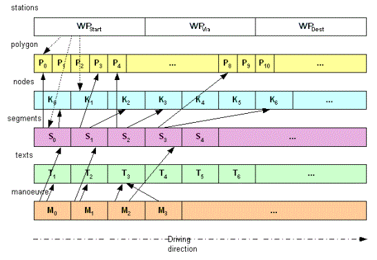
Route
Detailed route description with its different description elements
according to the options set in the ResultListOptions element.
The description elements are set to 'nil' when routing is based on identical stations. In this case the RouteInfo attributes (distance, time, cost) are set to 0.
To avoid redundancies in the data the single data array
elements are linked to each other as shown in the figure below. see picture
| Attribute Name | Type | Description |
|---|---|---|
info
|
RouteInfo
|
The summary information about distance and time. |
dynamicInfo
|
DynamicInfo
|
The optional travel time information in case of dynamic routing. |
stations
|
WayPoint[]
|
The array of the start, destination and via station descriptions. |
manoeuvres
|
RouteManoeuvre[]
|
The array of manoeuvres to be performed. The array might be null if ResultListOptions for manoeuvres are set to false. |
texts
|
String[]
|
An array of strings representing the string pool needed for this route. The array might be null if ResultListOptions for Texts are set to false. |
segments
|
RouteListSegment[]
|
An array of RouteListSegments representing the segment information for this route. The array might be null if ResultListOptions for segments are set to false. |
nodes
|
UniqueGeoID[]
|
An array of UniqueGeoID's representing the nodes information for this route. The array might be null if ResultListOptions for nodes are set to false. The array of nodes describing the route trajectory can be taken as an exeptionPath in the appropriate input parameter list when calculating an alternative route for example. |
polygon
|
LineString
|
A LineString object representing the polygon for this route, the actual waypoint coordinates are not included, but the match coordinates instead. The LineString Object might be null if ResultListOptions for polygons are set to false. |
binaryPathDesc
|
String
|
Describes the route path in a binary internal format. This is only because of a compact route path description when calculating alternative routes (see ExceptionPath). |
manoeuvreGroup
|
ManoeuvreGroup[]
|
An array of ManoeuvreGroups representing the extent of a ManoeuvreGroup the array might be null if ResultListOptions for ManoeuvreGroups are set to false |
boundingRectangles
|
BoundingRectangle[]
|
An array of BoundingRectangle representing the bounding rectangles around the calculated route. The array might be null if boundingRectanglesC in ResultListOptions are set to 0. |
totalRectangle
|
BoundingRectangle
|
Qn array of BoundingRectangle representing the bounding rectangles around the calculated route. The array might be null if boundingRectanglesC in ResultListOptions is set to 0. |
extSegments
|
String
|
Alternative description representing the route path (optional). This attribute is only set if the corresponding (optional) RouteListOption.extSegments is set to true AND at least one segment ID could be determined (see NOTE below). This is an external representation consisting of a list of provider's segment IDs (for example HERE). The syntax for this description is: LINESTRINGSEG(<segID> <dir> <countryCode>[,<segID> <dir> <countryCode>]*) <segID> = provider ID Example: NOTE: The SegmentIDs of certain countries will only be taken into account when the corresponding IDMapping layer could be initialized. (see logging of list of countries initialized when xRoute Server is started) |
emissions
|
Emissions
|
The emission of various substances for the complete route. The linking distance will not be considered. |
vehicleRelatedEmissions
|
Emissions
|
The vehicle related average emissions per kilometer are independent of the route. They only depend on the vehicle properties such as type or weight; they do not depend on the speed or inclination. This element will be returned for HBEFA 3.1 calculations only! |
cenEmissions
|
CENEmissionScenarios
|
The CEN or other factor-based emissions for this route. The linking distance will not be considered. |
RouteInfo
Summary information about a single route
Negative values in either the distance, time or costfield will cause error codes.
Example: If for example a 100 x 100 Matrix should be calculated and only one location cannot be linked to the roadnetwork due to linking restrictions, then only one single row and one single column cannot be calculated. In this case all these relations have negative values (error codes) in the distance and time fields.
Cost / distance / time will be set to "0" when all stations are identical in the request.
| Attribute Name | Type | Description |
|---|---|---|
distance
|
int
|
Travel distance in [m] (includes link distance). |
time
|
int
|
Travel time in [s] (includes link time) NOTE: 1) This time includes waiting times if the calculateTour method is used. 2) In case of a road blocking on the static route the dynamic time on static route resp. Td(Rs) is infinite. If so parameter time is set to -1 provided that DYNAMIC_TIME_ON_STATICROUTE is set to 'true'. 3) Otherwise negative values show error codes. Most common error codes here are -3120: At least one of the stations in the linking request could not be linked to the road network (coordinates might be outside of the map, far away from streets or close to streets which cannot be used for routing such as pedestrian zones, wood-paths and so on). -3211: No valid route found, one of the stations is located in an isolated area, or there is no route for the given restrictions, check the routing restrictions. Furthermore, -3211 is issued when this relation has not been calculated due to request abort. |
cost
|
int
|
The cost of the calculated route according to the given objective function. Unless stated otherwise in the referencing element this value contains a mathematical value rather than a monetary value, negative values show error codes. |
travelTrend
|
CommuterTravelTrend[]
|
The travel trend for commuters. This element is only present if the travel trend for commuters was requested (for example DYNAMIC_TRAVEL_TIME_STEP_COUNT > 1). |
hasViolations
|
Boolean
|
If true, the route has violations. A route can only have violations if violations have been explicitly enabled. For details see RoutingParameter ALLOW_SEGMENT_VIOLATIONS. |
RouteListSegment
Summary information about a route segment according to detailLevel STANDARD. See picture
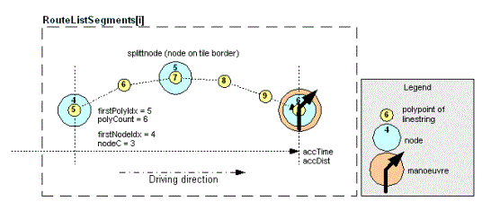
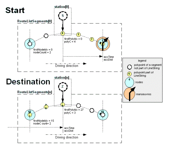
| Attribute Name | Type | Description |
|---|---|---|
firstPolyIdx
|
int
|
The index of the first point in the polygon array belonging to this segment. If no polygons have been returned, the index is -1. |
polyC
|
int
|
The number of polypoints belonging to this RouteListSegment starting with firstPolyIdx. |
firstNodeIdx
|
int
|
The index of the first node in the nodes array belonging to this segment. If no nodes have been returned, the index is -1. |
nodeC
|
int
|
The number of nodes belonging to this RouteListSegment starting with firstNodeIdx. |
streetNoIdx
|
int
|
The index of the Text representing the streetnumber in the texts array belonging to this segment. If no texts have been returned, the index is -1. |
streetNameIdx
|
int
|
The index of the text representing the StreetName in the texts array belonging to this segment. The index is -1 if no texts have been returned. |
dirInfoIdx
|
int
|
The index of the text representing the SignName in the texts array belonging to this segment. The index is -1 if no texts have been returned. |
accTime
|
int
|
The accumulated time in [s] up to the endpoint of the segment (might include waiting time at a station on this segment, except for the last station). When using the calculateTour service, the time comprises service, break, and rest at a station on the segment. The last segment ends at the last station and does not comprise a service period there. |
accDist
|
int
|
The accumulated distance in [m] up to the endpoint of the segment. |
nC
|
NetworkClass
|
The networkclass of this segment. |
vNorm
|
int
|
The normalized speed value in [km/h] classifying the segment as slow or fast segment. This is not the exact speed value taken in route calculation, but gives the relative speed of this segment in contrast to all other segments (DEPRECATED, always 0). |
normSpeed
|
NormSpeed
|
Describes the maximum speed on the route segment in [km/h]. Only if RoutingParameter SPEED_INFOS is true. Please note that this is not the speed limit. |
vCalc
|
Integer
|
The calculated speed on the route segment in [km/h]. Only if RoutingParameter SPEED_INFOS is true. For more information on speed values, please refer to the speeds documentation. |
iuCode
|
int
|
the integration unit code of the country this segment belongs to |
segmentAttr
|
SegmentAttributes
|
This group of output attributes is only set if it is requested in the RouteListOptions. |
countryCode
|
String
|
The optional country code information. If the RoutingParameter COUNTRY_ENCODING is not set, this attribute does not exist. |
emissions
|
Emissions
|
The emission of various substances for the segment. |
cenEmissions
|
CENEmissionScenarios
|
The CEN emissions for this segment.. |
speedLimits
|
SpeedLimits
|
The speed limits valid for this segment. |
violations
|
String[]
|
The blocking segment violations of the segment. The violations are returned in an array. Each violation is composed as follows: <ScopeType>:<Text of specific violation>That means for a map violation of blocked trucks the text would look like NetData:Blocks Trucks |
featureDescriptions
|
FeatureDescription[]
|
A list of feature descriptions valid for this segment. To receive this attribute the featureDescriptions attribute of ResultListOptions has to be set to true. Extra map data is needed to use this result attribute. |
utcOffset
|
Integer
|
The UTC offset (offset from Coordinated Universal Time +/-) is the difference in minutes from Coordinated Universal Time (UTC) at the endpoint of this segment. It includes the DST (Daylight saving time) if required for this segement. This attribute is optional and is only returned if 'utcOffsets' in ResultListOptions is set to true. |
RouteManoeuvre
The performed manoeuvre. The manoeuvre is located at the endpoint of its corresponding RouteListSegment (see picture of RouteListSegment).
| Attribute Name | Type | Description |
|---|---|---|
exitAngle
|
int
|
The angle of the outgoing road of the manoeuvre relative to the incoming road in [deg] (counterclockwise). |
exitAngleNorth
|
int
|
The angle of the outgoing road of the manoeuvre related to north in [deg] (clockwise). |
turnWeight
|
TurnWeight
|
The turn weight of the manoeuvre. |
turnOrient
|
TurnOrient
|
The turn orientation of the manoeuvre. |
exitNr
|
int
|
The exit number when the manoeuvre is located at a roundabout. |
manoeuvreType
|
ManoeuvreType
|
The manoeuvre type. |
detailLevel
|
DetailLevel
|
The detail level to which this manoeuvre belongs to. |
dirInfoNodeType
|
InfoNodeType
|
The type of the direction info at this manoeuvre. |
dirInfoIdx
|
int
|
An array-index of the direction info text. |
locInfoNodeType
|
InfoNodeType
|
The type of the location info at this manoeuvre. |
locInfoIdx
|
int
|
The array-index of the location info text. |
routeListSegmentIdx
|
int
|
The index of the corresponding RouteListSegment. |
predSegmentIdx
|
int
|
The array index of the preceding RouteListSegment RouteManoeuvre. |
succSegmentIdx
|
int
|
The array index of the succeeding RouteListSegment. |
manoeuvreDesc
|
String
|
The manoeuvre description text in the requested route language (see RoutingOptions). |
manoeuvreAttr
|
ManoeuvreAttributes
|
Optional manoeuvre attributes. This group of output attributes is only set if it is requested in the RouteListOptions and if at least one of the attributes is set. |
urbanlManoeuvre
|
UrbanManoeuvre
|
Optional manoeuvre description for manoeuvres generated when entering or leaving a city. This group of output attributes is only set if it is requested in the RouteListOptions and if at least one of the attributes is set. |
brunnelManoeuvre
|
BrunnelManoeuvre
|
Optional manoeuvre description for manoeuvres generated when entering or leaving a tunnel or a bridge (brunnel). In this case a manoeuvre after a tunnel can refer to a tunnel or a bridge just passed, for example: bear right 100 meters after the bridge. This group of output attributes is only set if it is requested in the RouteListOptions and if at least one of the attributes is set. |
manoeuvreGroupIdx
|
int
|
An array-index of the corresponding ManoeuvreGroup. |
viaIdx
|
int
|
An array-index of the corresponding WayPoint. -1 if there is no direct corresponding WayPoint. This index always points to the WayPoint just passed. The WayPoint is located between this and the previous manoeuvre except this is the last manoeuvre. In this case the WayPoint is located after this manoeuvre. |
RoutingOption
Represents one routing option. The option type is described by the enumeration RoutingParameter.
| Attribute Name | Type | Description |
|---|---|---|
parameter
|
RoutingParameter
|
The routing option to be set. |
value
|
String
|
The according value for the routing option. Legal values depend on the RoutingParameter. |
SegmentAttributes
Additional attributes of a single RouteListSegment.
| Attribute Name | Type | Description |
|---|---|---|
brunnelCode
|
BrunnelCode
|
Describes if this segment belongs to a tunnel or bridge and describes the type. |
isFerry
|
boolean
|
If true, this segment represents a ferry, otherwise a piggyback train connection. If ResultListOption segmentAttributePiggyback is true, this attribute is true only if the segment represents a ferry. Otherwise (default) this attribute is true if the segment represents a ferry or a piggyback. |
isBlockedCar
|
boolean
|
If true, this segment is blocked for cars. |
isBlockedTruck
|
boolean
|
If true, this segment is blocked for trucks. |
hasTollCar
|
boolean
|
If true, this segment is a toll road for cars. |
hasTollTruck
|
boolean
|
If true, this segment is a toll road for trucks. |
hasVignetteCar
|
boolean
|
If true, this segment is a vignette road for cars |
hasVignetteTruck
|
boolean
|
If true, this segment is a vignette road for trucks. |
hasExtraToll
|
boolean
|
If true, this segment has extra toll. |
hasNamedToll
|
Boolean
|
If true, this segment has named toll. This attribute is only present if ResultListOption segmentAttributeNamedToll is true. Otherwise (default) this attribute is not present. |
hasSeparator
|
boolean
|
If true, the road of this segment has a divider (is currently always false). |
isPedestrianZone
|
boolean
|
If true, the road of this segment is a pedestrian zone. |
additionalRE
|
String
|
Indicates optional road editor information given as semicolon separated key-value pairs according to the RoadEditor properties set for the corresponding segment in the additional road editor database. Possible keys are given in RoadEditorOptions If no road editor information is requested, this attribute does not exist. Example: << key1|dir1 >>=<>,<< key2|dir2 >>=<< value2 >>,...,<< keyn|dirn >>=<< valuen >> dir = 0, the segment is given in opposite direction dir = 1, the segment is given in driving direction EXT_INFO|0=1,IS_RAMP|1=1,OPT_MALUS1|1=-50 |
additionalInfo
|
String
|
Represents optional additional - not documented - Information for project purposes. |
lowEmissionZoneType
|
String
|
The low emission zone is presented by one of the these identifiers:
|
isPiggyback
|
Boolean
|
Describes if this segment represents a piggyback. This attribute is only present if ResultListOption segmentAttributePiggyback is true. Otherwise (default) this attribute is not present. |
SpeedLimit
Speed limits are not available for all segments. Dependent on the map provider only some speed limits may be free of charge and not all maps contain speed limits, at all. For more information on the availability and licensing contact your PTV representative.
These speed limits represent the signs on the roads, they have not been used to calculate the travel speed on this segment during routing calculation.
For more information on format of the condition string see the use-case documentation.
| Attribute Name | Type | Description |
|---|---|---|
limitVelocity
|
int
|
The speed limit itself in [km/h]. |
condition
|
String
|
The condition under which the speed limit is valid. |
SpeedLimits
| Attribute Name | Type | Description |
|---|---|---|
speedLimit
|
SpeedLimit[]
|
The array of speed limits. |
TimeEvent
| Attribute Name | Type | Description |
|---|---|---|
type
|
TimeEventType
|
The type of event. |
startTime
|
int
|
The start time of the event which might become negative if remaining driving times are given and the current tour does not follow the previous one immediately. The time in-between can then be used for a break or a rest. |
period
|
int
|
The period of the event. |
tourPointIdx
|
int
|
The zero-based index of this event in the tour point array of the Tour element. |
segmentIdx
|
int
|
The zero-based index of this event in the stations array of the Route element. This is particularly interesting if the event does not occur at a tour point but on the road instead. The segment index of the last tour point is invalid as there is no segment beginning at the last tour point. |
TollCost
| Attribute Name | Type | Description |
|---|---|---|
cost
|
int
|
The cost. |
currency
|
Currency
|
The currency of the toll prices. Deprecated, use attribute currencyISOCode instead. |
currencyISOCode
|
String
|
The ISO 4217 code of the currency in case there is toll data for this country available. This is an optional attribute and is only set if 'currencyDescription' in CountryInfoOptions is true. |
currencyName
|
String
|
The currency name of the requested language in case there is toll data for this country available. This is an optional attribute and is only set if 'currencyDescription' in CountryInfoOptions is true. |
iuCode
|
int
|
The integration unit code . |
type
|
TollType
|
The type of the toll. |
TollCostInfo
The detailed toll costs for each country, each element represents a toll section. The toll is calculated by distance for some countries and globally (vignette) for some other countries. Those countries with global toll do not divide the route into toll sections, for example the tollSectionID equals -1, and the elements tollStationFrom and tollStationTo do not contain proper values.
In Austria there might be duplicate entries with different tollType values. In that case those with tollType SPECIALCHARGE are relevant.
| Attribute Name | Type | Description |
|---|---|---|
tollStationFrom
|
TollStationDescription
|
If tollSectionID does not equal -1, this element contains information on the start point of this toll section. |
tollStationTo
|
TollStationDescription
|
If tollSectionID does not equal -1, this element contains information on the end point of this toll section. |
tollSectionID
|
int
|
ID for the toll section. -1 if this country has global toll (vignette). |
tollSectionName
|
String
|
The name for the toll section according to the sectionID. Empty if this country has global toll (vignette). This is an optional attribute and is only set if the REQUEST_VERSION is set to 1.4.5 or higher |
tollProviderID
|
int
|
ID for the toll company. |
tollProviderName
|
String
|
The toll provider name according to the providerID. This is an optional attribute and is only set if the REQUEST_VERSION is set to 1.4.5 or higher. |
streetName
|
String
|
The street name. This is an optional attribute and is only set if the REQUEST_VERSION is set to 1.4.5 or higher. |
tollDistance
|
int
|
Distance of the toll section in [m]. |
tollPrice
|
int
|
Price for the toll section (can be 0 for citytoll/vignette in case of reentering). The price is given in subunits of the currency, for example if currency is Euro, the price is given in Eurocents. If the currency consists of 1000 subunits, the price is given in 10 subunits. |
tollType
|
TollType
|
Kind of the toll section (for example national toll or extra toll). |
vehicleTarifID
|
Integer
|
For internal use only. This is an optional attribute and is only set if the REQUEST_VERSION is set to 1.4.5 or higher. |
currency
|
Currency
|
The currency of the toll prices. Deprecated. |
currencyName
|
String
|
Represents the currency description. This is an optional attribute and is only set if the REQUEST_VERSION is set to 1.4.5 or higher. |
waypointIndex
|
Integer
|
Index of the waypoint to which this toll section is assigned to. This value is only filled if the CountryInfoOptions.waypointIndexInTollCostInfo is set to true in the request. |
TollScenario
| Attribute Name | Type | Description |
|---|---|---|
iuCode
|
int
|
The integration unit code for this scenario. |
scenarioId
|
int
|
The unique key to identify the scenario. |
TollStationDescription
Describes information of toll station.
| Attribute Name | Type | Description |
|---|---|---|
tollStationName
|
String
|
The name of the toll station. |
tollStationID
|
int
|
The identifier of the toll station. |
tollLocationType
|
InfoNodeType
|
Type of the location info at this toll station. |
routeListIndex
|
int
|
The index in the routelist where this tollsection starts or ends. It has the value -1 if there is no toll station. This is for countries in which the toll depends on the distance. |
time
|
String
|
The time String representing the time for entering or leaving the according toll section. This is an optional attribute and is only set if the REQUEST_VERSION is set to 1.4.5 or higher. |
manoeuvreType
|
TollManoeuvreType
|
Optional attribute describing the manoeuvre type. Is either ENTER, EXIT, FURTHER or CHANGE. |
TollTotals
| Attribute Name | Type | Description |
|---|---|---|
distance
|
int
|
The total toll distance within a country in [m]. This value indicates the distance given by the toll provider. |
cost
|
int
|
The total toll costs within a country. |
Tour
Extends ExtendedRoute
| Attribute Name | Type | Description |
|---|---|---|
tourPoints
|
TourPoint[]
|
The tour points. |
timeEvents
|
TimeEvent[]
|
The list of events occurred during the tour. |
tourSummary
|
TourSummary
|
The tour summary. |
TourEvent
| Attribute Name | Type | Description |
|---|---|---|
tourPointIndex
|
int
|
Index of the tour point at which the event takes place, or -1 if the event takes place on the road. |
startTime
|
Calendar
|
Start time of this event. |
period
|
int
|
Period of this event. |
descriptions
|
String[]
|
An array of TourEventDescriptions for this event. See TourEventDescription for details. This enumeration may be extended without further notice. Client applications must ignore unknown values. |
violations
|
String[]
|
An array of TourEventViolations for this TourEvent. See TourEventViolation for details. This enumeration may be extended without further notice. Client applications must ignore unknown values. |
segmentIndex
|
int
|
Segment index of the tour point at which the event takes place. As with WayPoint attribute segmentIdx this index is invalid if it takes place at the last station. |
TourOptions
| Attribute Name | Type | Description |
|---|---|---|
startIntervalLength
|
Integer
|
The length of the start interval. The earliest point in time when the tour can be started, is the time given by RoutingParameter START_TIME. If startIntervalLength is present, this value specifies within what time period (in [s]) after the start time the tour can be started. 0 means that the tour must be started at the specified start time, 600 means the tour can be started within 10 minutes after the start time. Leave this value empty in order not to restrict the start time, at all. |
operatingIntervals
|
Interval[]
|
The time intervals in which the driver is allowed to operate (to drive or to perform active service). Outside of these intervals, a driver must rest. The intervals must be disjoint and must be ordered strictly ascending. |
restrictToSingleOperatingInterval
|
boolean
|
If true, all active service and driving with a duration greater than zero must take place within the same operating interval. By default, the restriction is disabled. |
tourRestrictions
|
TourRestrictions
|
This attribute stores some restrictions which should be applied to the calculation. |
useCase
|
String
|
This attribute specifies an internal optimization method. Adjust this value in collaboration with PTV's support only. |
driverSettings
|
DriverSettings
|
The individual driver regulation settings. |
regulations
|
RegulationsBase
|
Regulations to respect when calculating a tour.
This value must be set to null if remainingPeriods in driverSettings are set, because remainingPeriods contain the DriverRegulations from a previous tour and can not be changed. By default, the regulations of the EU as described in DriverRegulations will be active. |
TourPoint
| Attribute Name | Type | Description |
|---|---|---|
arrivalTime
|
int
|
The arrival time at this tour point. |
startOfService
|
int
|
Start of service. |
endOfService
|
int
|
End of service. |
departureTime
|
int
|
The departure time. |
stationIdx
|
int
|
The zero-based index of this tour point in the stations array of the Route element. |
timeWindowViolation
|
boolean
|
If true, the tour could not be calculated matching all parameters. Arrival (and complete service if needed) is not within the opening intervals. |
serviceViolation
|
boolean
|
If true, the tour could not be calculated matching all parameters. The complete service period is not within the opening intervals. |
TourPointDesc
Extends WaypointDesc
| Attribute Name | Type | Description |
|---|---|---|
servicePeriod
|
int
|
The service period at this tour point in [s]. |
openingIntervals
|
Interval[]
|
The opening intervals at this tour point. The route will be calculated in a way so that arrival (and the service period if need be) will be within the opening intervals. The intervals must be disjunct, ascending and they must end after the start of the route. This element can be nil, in that case arrival can be anytime. |
useServicePeriodForRecreation
|
boolean
|
If true, the driver must not help unloading a truck. If set to false, it can be assumed that the driver has to work during the whole service period. If set to true, the driver for example waits while someone else unloads the truck. This means if the service-period is longer than the minimum period required for a break, the driver can use the service period as a break (or rest). |
completeServiceInIntervals
|
boolean
|
If true, arrival and complete service period must be within the opening intervals, otherwise only arrival must be within. |
siteID
|
Integer
|
For each tour point a siteID > 0 can be provided. Tour points with the same siteID refer to the same physical location. For example, this could model multiple deliveries to the same company. Leave empty if necessary. |
minUninterruptedServicePeriod
|
Integer
|
Specifies the minimum uninterrupted period of service. If not present, the service can be interrupted at any time. |
TourPointResult
| Attribute Name | Type | Description |
|---|---|---|
arrivalTime
|
Calendar
|
Time of arrival at this tour point. |
startServiceTime
|
Calendar
|
Beginning of the service at this tour point. |
endServiceTime
|
Calendar
|
End of the service at this tour point. If the Site-ID is == Constants::UNDEFINED_SITE_ID(), the feature is not active. |
departureTime
|
Calendar
|
Time of departure from this tour point (equals end of service at final tour point). |
genuineWaitingPeriod
|
int
|
Period of time at this tour point that is used neither for recreation nor for service, for example for waiting only. |
recreationPeriodsOnRoad
|
RecreationPeriods
|
Summary of all recreation periods between departure from previous and arrival at this tour point. |
recreationPeriodsAtTourPoint
|
RecreationPeriods
|
Summary of all recreation periods between arrival and departure at this tour point. |
stationIndex
|
int
|
The zero-based index of this tour point in the stations array of the Route element. |
TourRestrictions
| Attribute Name | Type | Description |
|---|---|---|
transportPeriodRestrictions
|
TransportPeriodRestriction[]
|
An array containing transport period restrictions. Each entry contains a source/start tour point and a sink/end tour point index together with the max. transport period between these two tour points. |
maxTourPeriod
|
Integer
|
Specifies the maximum duration of the tour. The duration of the tour is the period of time from the beginning of the first service up to the completion of the final service. Idle periods at the beginning of the tour before the first service do not increase the tour period. The above statement does not hold for all idle periods after the end of the given start interval. All tour events behind the end of the start interval increase the overall tour period. If not present, there will be no restriction. |
TourSummary
| Attribute Name | Type | Description |
|---|---|---|
totalPeriod
|
int
|
The total period of the tour. |
drivingPeriod
|
int
|
The total driving period. |
waitingPeriod
|
int
|
The total waiting period. |
earliness
|
int
|
The total time the driver arrived at a tour point before the opening times. |
servicePeriod
|
int
|
The total service period. |
idlePeriod
|
int
|
The total idle period. |
latestTourStart
|
Calendar
|
The latest point of time at which the tour must be started in order to arrive on time at the last tour point. Will be nil if no opening intervals are given. |
remainingShiftPeriod
|
Integer
|
The remaining shift period. Only set if RoutingOption REMAINING_DRIVING_TIMES is present. |
remainingWorkingHoursDuringShift
|
Integer
|
The remaining working hours during current shift. Only set if RoutingOption REMAINING_DRIVING_TIMES is present. |
remainingDrivingTimeBeforeNextBreak
|
Integer
|
The remaining driving time before the next break. Only set if RoutingOption REMAINING_DRIVING_TIMES is present. |
remainingBreakPeriod
|
Integer
|
The remaining break period. Only set if RoutingOption REMAINING_DRIVING_TIMES is present. |
TransportPeriodRestriction
| Attribute Name | Type | Description |
|---|---|---|
startTourPointIndex
|
int
|
The source/start logistic point. |
destinationTourPointIndex
|
int
|
The sink/end logistic point. |
maxPeriodBetweenServices
|
int
|
The maximum transport period between the two logistic points. |
UKDefra2014
Extends CENEmissions
| Attribute Name | Type | Description |
|---|---|---|
energyUseTank2Wheel
|
double
|
The energy use tank-to-wheel in [MJ]. |
co2eTank2Wheel
|
double
|
The CO2e tank-to-wheel in [kg]. |
co2eWell2Wheel
|
Double
|
The CO2e well-to-wheel calculation in [kg]. |
co2Tank2Wheel
|
double
|
The CO2 tank-to-wheel in [kg]. |
ch4Tank2Wheel
|
double
|
The CH4 (methane) tank-to-wheel in [g]. |
n2oTank2Wheel
|
double
|
The N2O (Nitrous oxide) tank-to-wheel in [g]. |
UniqueGeoID
A node in the roadnetwork specified by its geographical xyn-position.
| Attribute Name | Type | Description |
|---|---|---|
tID
|
long
|
The tile ID where this UniqueGeoID is located. |
xOff
|
int
|
The x-offset adress of this UniqueGeoID. |
yOff
|
int
|
The y-offset adress of this UniqueGeoID. |
n
|
int
|
The n-level of this UniqueGeoID. |
iuCode
|
int
|
The integration unit code where this node is located. For example: 49 - germany; 33 - france; 34 - spain |
UrbanManoeuvre
Describes an additional urban manoeuvre.
| Attribute Name | Type | Description |
|---|---|---|
urbanIdx
|
int
|
The array index of the urban description text. |
additionalUrbanIdx
|
Integer
|
An optional array index of an additional urban description text. This index is only set if a manoeuvre has set the ManoeuvreAttribute.isUrbanStart and ManoeuvreAttribute.isUrbanEnd at the same time. In this case urbanIdx holds the index to the text of the urban area just left while additionalUrbanIndex holds the index to the urban area just entering |
VehicleOption
| Attribute Name | Type | Description |
|---|---|---|
parameter
|
VehicleParameter
|
The string representation of the enumeration value VehicleParameter |
value
|
String
|
The value of the VehicleParameter |
ViaType
| Attribute Name | Type | Description |
|---|---|---|
viaType
|
ViaTypeEnum
|
The type of the via point. |
WayPoint
A station waypoint for start, destination or via-stations.
| Attribute Name | Type | Description |
|---|---|---|
accTime
|
int
|
The accumulated time in [s] up to this station (arrival time), the first station has accTime = 0, the last station has accTime = routeInfo.time - link time. When using the calculateTour service, the arrival time does not comprise service, break, and rest at this station. This also applies to the last station; if there is a service period given, accTime + service period = routeInfo.time. Please use the corresponding TourPoint element for more information on arrival, service, and departure times. |
accDist
|
int
|
The accumulated distance in [m] up to this station. The first station has accDist = 0. The last station has accDist = routeInfo.distance - link distance. |
iuCode
|
int
|
The integration unit code of the country in which this station is located. |
polyIdx
|
int
|
The index in the polygon pointing to the polypoint right behind the station. For example if the polyIdx = 5, the station is located between polyIdx = 4 and polyIdx = 5 |
nodeIdx
|
int
|
The index in the nodes array pointing to the node right behind the station. For example if the nodeIdx = 5 the station is located between nodeIdx = 4 and nodeIdx = 5. |
segmentIdx
|
int
|
The zero-based index in the segments-array pointing to the segment to which the station was linked. The coordinate of the segment is its beginning, but time and distance values are its end. Therefore accTime and accDist of this station are less or equal the respective values of the segment, and the location lies after the beginning of the segment. As there is no segment beginning at the last station, this index is invalid for the last station. Breaks, rests, and service periods calculated by calculateTour are added to the segment where the station was linked. |
manoeuvreIdx
|
int
|
The zero-based index in the manoeuvre-array pointing to the manoeuvre right after the station. As there is no manoeuvre after at the last station, this index is invalid for the last station. |
locationCoord
|
Point
|
The coordinates of the location. |
matchCoord
|
Point
|
The coordinates of the link point (the intersection point of the perpendicular with the segment). |
wayPointType
|
WayPointType
|
The WayPointType of this waypoint. |
countryCode
|
String
|
The optional country code information. If the RoutingParameter COUNTRY_ENCODING is not set, this attribute does not exist. |
emissions
|
Emissions
|
The accumulated amount of emissions of various substances. |
cenEmissions
|
CENEmissionScenarios
|
The accumulated CEN emissions for this waypoint. |
utcOffset
|
Integer
|
The UTC offset (offset from Coordinated Universal Time ±) is the difference in minutes from Coordinated Universal Time (UTC) at this waypoint. It includes the DST (Daylight saving time) if required for this waypoint. This attribute is optional and is only returned if 'utcOffsets' in ResultListOptions is set to true. |
WaypointDesc
Describes coordinates and the linktype of the location which has to be linked to the road network. Please consider the restrictions described with the attributes.
| Attribute Name | Type | Description |
|---|---|---|
coords
|
Point[]
|
The coordinates of the location which have to be linked to roadnetwork. In case of a multilink, this can also be an array of coordinates treated as entrypoints for one single waypoint. |
linkType
|
LinkType
|
The linktype for the location which has to be linked to the roadnetwork. |
nodeID
|
UniqueGeoID
|
The unique key to identify the node to which explicitly has to be linked. This attribute is optional and does not need to be set. Explicit linking to a node is not allowed for the methods calculateMatrixInfo, calculateIsochrones, and calculateReachableObjects. |
segmentID
|
UniqueGeoID[]
|
The unique keys to identify the pair for the segment to which explicitly has to be linked. This attribute is optional and does not need to be set. Explicit linking to a segment is not allowed for the methods calculateMatrixInfo, calculateIsochrones, and calculateReachableObjects. |
fuzzyRadius
|
int
|
The radius for fuzzy linking to a certain location in [m]. The resulting via point may now be one of the nodes which can be reached within the given road distance from the co-ordinate. Be careful when using small values close to motorways. In that case it is very likely that the motorway is within the radius but none of the exits. This algorithm uses a heuristic method, thus the result might not be the optimal solution especially when using several fuzzy waypoints one after the other.. This value is only interpreted for via-points with linkType FUZZY_LINKING in 1:1 routing requests and not when calculating a matrix. Legal values are >=0, the default is 0. |
heading
|
Integer
|
The angle which specifies an additional constraint when linking a certain location to the road network. This means that the location will be linked to the geographically nearest segment which has approximately the same orientation as described in the heading. The tolerance can be given in the profile. Legal angle values are 0 to 360 related to north in [deg] (clockwise). This parameter is optional and has only an effect when using LinkType NEXT_SEGMENT, AUTO_LINKING or TI_LINKING and headingTolerance being configured in the profile. |
street
|
String
|
A street name respectively street number which specifies an additional constraint when linking a certain location to the road network. <streetname>[/<streetname>]* |
routingOptions
|
RoutingOption[]
|
The specific attributes for routing, up to the next waypoint. These options can only be used in the methods calculateRouteInfo(), calculateRoute(), calculateExtendedRoute() and calculateTour() of XRoute, otherwise the exception UNSUPPORTED_WAYPOINT_CONFIGURATION is thrown. There are routing parameters which must not be used here. See RoutingParameter, otherwise the exception INVALID_WAYPOINT_CONFIGURATION is thrown. Options are not allowed at fuzzy waypoints or combined transports, otherwise the exception UNSUPPORTED_WAYPOINT_CONFIGURATION is thrown. |
vehicleOptions
|
VehicleOption[]
|
The vehicle specific attributes, up to the next waypoint. These options can only be used in the methods calculateRouteInfo(), calculateRoute(), calculateExtendedRoute() and calculateTour() of XRoute, otherwise the exception UNSUPPORTED_WAYPOINT_CONFIGURATION is thrown. Options are not allowed at fuzzy waypoints or combined transports, otherwise the exception UNSUPPORTED_WAYPOINT_CONFIGURATION is thrown. |
viaType
|
ViaType
|
The type of the via point. Must be NULL for start and destination, otherwise the exception CONFLICT_VIA_TYPE is thrown. This type can only be used in the methods calculateRouteInfo(), calculateRoute(), calculateExtendedRoute() and calculateTour() of XRoute, otherwise the exception UNSUPPORTED_WAYPOINT_CONFIGURATION is thrown. Fuzzy waypoints and combined transports must not be used with TourPointDesc, otherwise the exception CONFLICT_TOUR_FUZZYPOINTS is thrown. The default value is VIA. |
combinedTransportID
|
String
|
The unique key to identify a ferry or a piggyback transport. If the viaType COMBINED_TRANSPORT is selected, this attribute must be set. If combinedTransportID is set, the attribute coords must be null. Otherwise an exception is thrown. |
WeeklyRestRule
| Attribute Name | Type | Description |
|---|---|---|
maximumPeriodBetweenWeeklyRests
|
int
|
Maximum period between the end of a weekly rest period and the beginning of the following weekly rest period. Remarks: According to EU regulation : 6d (518400s) |
maximumWeeklyDrivingPeriod
|
int
|
Cumulative period of time a driver is allowed to drive within a week. Remarks: According to EU regulation : 56h (201600s) |
maximumBiweeklyDrivingPeriod
|
int
|
Cumulative period of time a driver is allowed to drive within two weeks. Remarks: According to EU regulation : 90h (324000s) |
weeklyRestPeriod
|
int
|
Minimum period of time of a weekly rest. Remarks: According to EU regulation : 45h (162000s) |
WeeklyRestRuleAUS
| Attribute Name | Type | Description |
|---|---|---|
weeklyRestPeriod
|
int
|
Minimum duration of a required weekly rest. Remark: According to NTC_AUS regulation: 24h (86400 s) |
maximumWeeklyWorkingPeriod
|
int
|
Maximum working period which cannot be exceeded in one week (7d or 168h). Remark: According to NTC_AUS regulation: 72h (259200 s) |
WorkingRule
| Attribute Name | Type | Description |
|---|---|---|
breakPeriod
|
int
|
Minimum duration of required working break. Remarks: According to German working hours regulation: 30m (1800s) |
extendedBreakPeriod
|
int
|
Minimum duration of extended break if workingPeriod exceeded. Remarks: According to German working hours regulation: 45m (2700s) |
maxWorkingPeriodWithoutBreak
|
int
|
Maximum duration of uninterrupted working time without having a break. Remarks: According to German working hours regulation: 6h (21600s) |
maxWorkingPeriodWithoutExtendedBreak
|
int
|
Maximum duration of uninterrupted working time without having an extended break. Remarks: According to German working hours regulation: 9h (32400s) |
minPartialBreakLength
|
int
|
Minimum duration break part if break is split. Remarks: According to German working hours regulation: 15m (900s) |
maxWorkingPeriodWithoutDailyRest
|
int
|
Maximum working period after which a daily working rest must be done. Remarks: According to German working hours regulation: 8h - 10h (28000s - 36000s) |
maxWorkingPeriodPerWeek
|
int
|
Maximum working period in a week. Remarks: According to German working hours regulation: 48h - 60h (172800s - 216000s) |
dailyRestPeriod
|
int
|
Minimum uninterrupted daily rest period after work. Remarks: According to German working hours regulation: 11h (39600s) |
BrunnelCode
The type of the tunnel or bridge.
| Enumerator Name | Value | Description |
|---|---|---|
NOTHING
|
0 |
No tunnel or bridge. |
OVER_WATER
|
1 |
Bridge over water. |
UNDER_WATER
|
2 |
Tunnel under water. |
OVER_TRAIN
|
3 |
Bridge over railways. |
UNDER_TRAIN
|
4 |
Tunnel under railways. |
OVER_STREET
|
5 |
Bridge over a street. |
UNDER_STREET
|
6 |
Tunnel under a street. |
BRIDGE
|
7 |
Bridge without any further description. |
TUNNEL
|
8 |
Tunnel without any further description. |
CENVersion
| Enumerator Name | Value | Description |
|---|---|---|
CEN_2011
|
0 |
The CEN calculation based on values from 2011 (EN16258:2011). |
CEN_2012
|
1 |
The CEN calculation based on values from 2012 (EN16258:2012). |
CO2_DECREE_FRANCE_2011
|
2 |
The French CO2 decree no. 2011-1336, Article L.1431-3:2011. Only the following biofuel blends are supported: E10, E85 and B30. These blends can be set using the VehicleParameters FUEL_TYPE and BIO_FUEL_RATIO. For example E10 is represented by FUEL_TYPE=EUROSUPER and BIO_FUEL_RATIO=10. B30 is set by FUEL_TYPE=DIESEL and BIO_FUEL_RATIO=30. |
CO2E_DECREE_FRANCE_2017
|
3 |
The French CO2e decree no. 2017-639. Only the following biofuel blends are supported: E10, E85 and B30. These blends can be set using the VehicleParameters FUEL_TYPE and BIO_FUEL_RATIO. For example E10 is represented by FUEL_TYPE=EUROSUPER and BIO_FUEL_RATIO=10. B30 is set by FUEL_TYPE=DIESEL and BIO_FUEL_RATIO=30. |
AUSTRALIA_NGA_2011
|
4 |
The emission calculation based on the Australian National Greenhouse Accounts (NGA), factors July 2011. To specify the emission class and the year of manufacture for each vehicle. |
UK_DEFRA_2014
|
5 |
The emission calculation based on the emission factors provided by the Department for Environment, Food & Rural Affairs (Defra) in the United Kingdom, factors 2014. |
AUSTRALIA_NGA_2015
|
6 |
The emission calculation based on the Australian National Greenhouse Accounts (NGA), factors December 2015. To specify the emission class and the year of manufacture for each vehicle. |
Currency
The different currencies to choose. Some of these currencies do not exist anymore. They are kept anyway, otherwise backward-compatibility with older xRoute clients is not assured.
| Enumerator Name | Value | Description |
|---|---|---|
NONE
|
0 |
none - not defined. |
EUR
|
1 |
Euro |
GBP
|
2 |
British pound (sterling) - United Kingdom |
DKK
|
3 |
Danish krone - Denmark, Greenland |
NOK
|
4 |
Norwegian krone - Norway |
SEK
|
5 |
Krona - Sweden |
CHF
|
6 |
Swiss franc - Switzerland, Liechtenstein |
PLN
|
7 |
Polish z?oty - Poland |
SIT
|
8 |
Tolar - Slovenia |
SKK
|
9 |
Slovak koruna - Slovakia |
SK
|
10 |
Icelandic krona - Iceland |
TRY
|
11 |
Turkish new lira - Turkey |
USD
|
12 |
United States dollar |
CAD
|
13 |
Canadian dollar - Canada |
JPY
|
14 |
Yen - Japan |
ROL
|
15 |
Romanian leu - Romania |
BGN
|
16 |
Lev (Лев) - Bulgaria |
HUF
|
17 |
Forint - Hungary |
HRK
|
18 |
Kuna - Croatia |
MKD
|
19 |
Denar - North Macedonia |
ALL
|
20 |
Lek - Albania |
BAM
|
21 |
Bosnian and Herzegovinian konvertibilna marka - Bosnia and Herzegovina |
EEK
|
22 |
Kroon - Estonia |
CSD
|
23 |
Serbian dinar - Serbia |
LVL
|
24 |
Lat - Latvia |
LTL
|
25 |
Litas - Lithuania |
MTL
|
26 |
Maltese lira - Malta |
MDL
|
27 |
Moldovan leu - Moldova |
CYP
|
28 |
Cyprus pound - Cyprus |
ZAR
|
29 |
Rand - South Africa |
CZK
|
30 |
Czech Koruna - Czech Republic |
DetailLevel
Describes different detail levels which can be requested.
| Enumerator Name | Value | Description |
|---|---|---|
BORDERS
|
0 |
Only Borders |
VERY_IMPORTANT
|
1 |
The entering, leaving and changing of highways; The entering of ferries. |
STANDARD
|
2 |
All manoeuvres. |
LESS_IMPORTANT
|
3 |
All road changes. |
OTHER_OPPORTUNITIES
|
4 |
The nodes with more than one trailing segment. |
ORTHOGONAL
|
5 |
An additional manoeuvre. This level cannot be requested. All manoeuvres which are additional manoeuvres have detail ORTHOGONAL(like brunnel manoeuvres). |
ALL
|
6 |
All the rest. |
EmissionLevel
| Enumerator Name | Value | Description |
|---|---|---|
NONE
|
0 |
No emission calculation. |
BASIC
|
1 |
Only the total amount of emissions. |
SEGMENTS
|
2 |
The total amount of emissions and the emissions per segment. |
STATIONS
|
3 |
The total amount of emissions and the emissions per station. |
ALL
|
4 |
The total amount of emissions and the emissions per segment and per station. |
ErrorCode
The error codes which can occur in the PTV xRoute Server.
If an error occurs, see the logfile for further detailed error descriptions.
| Enumerator Name | Value | Description |
|---|---|---|
SUCCESS
|
0 |
Calculation successful. |
USER_ABORT
|
-1 |
The user aborted the request. |
GENERAL_ENGINE_ERROR
|
2000 |
Deprecated. This error will not be used anymore. |
GENERAL_INITIALIZATION_ERROR
|
2010 |
Deprecated. This error will not be used anymore. |
PROFILE_DOES_NOT_EXIST
|
2020 |
This error will not be used anymore. |
INVALID_TIMECALC_PROFILE
|
2030 |
Deprecated. This error will not be used anymore. |
GENERAL_CALCULATION_ERROR
|
2040 |
Deprecated. This error will not be used anymore. |
INVALID_PROPERTY_ERROR
|
2050 |
Deprecated. This error will not be used anymore. |
INVALID_OPTION_ERROR
|
2060 |
An attribute contains an invalid enumeration value. Please check the request. |
INVALID_LINK_TYPE
|
2070 |
At least one station has link type NEXT_MAIN_TOLL_NODE which is not supported anymore |
INVALID_EXPANSION_DESCRIPTION
|
2080 |
Expansion description invalid, the horizons are not in increasing order. |
INVALID_NETWORKCLASS_DIMENSION
|
2090 |
The network class filter-array exceeds dimension. |
CONFLICTING_PROPERTIES_ERROR
|
2100 |
Deprecated. This error will not be used anymore. |
CONFLICTING_OPTIONS_ERROR
|
2110 |
Conflicting options in request. |
GENERAL_LICENSE_ERROR
|
2120 |
General license error. Licence is not valid or expired. Check license contents. |
BINARY_PATH_DESC_CORRUPT
|
2150 |
The binary path description is corrupt. |
EXCEPTIONPATH_POLYLINE_CANNOT_BE_USED
|
2155 |
The polyline representation of an exception path can currently only be used in combination with a relative malus of -99. |
EXCEPTIONPATH_POLYLINE_TOO_LONG
|
2156 |
Maximum length of the exception path's polyline exceeded. |
CONFLICT_MATRIX_EXPATH_STREET
|
2157 |
The service method calculateMatrixInfo() does not support an exception path containing a street name. |
DYNAMIC_TIME_ON_STATICROUTE_NOT_SUPPORTED
|
2158 |
The service methods calculateMatrixInfo(), calculateIsochrones(), calculateReachableObject(), and searchForReachableObjects() do not support RoutingParameter DYNAMIC_TIME_ON_STATICROUTE. |
INACCURATE_EXCEPTIONPATH_DESC
|
2160 |
Inaccurate path descriptions in ExceptionPath, neither representation could be considered. |
EXCEPTIONPATH_INTERSECTINGLINE_CANNOT_BE_USED
|
2161 |
The intersecting line has to be a linestring containing exactly two points. |
WAYPOINTDESC_WITHOUT_COORDS
|
2170 |
Error in WaypointDesc object: no coordinates set. |
WAYPOINTDESC_EXPLICITLINKING_AND_COORDS
|
2171 |
Error in WaypointDesc object: explicit linking (segmentID or nodeID set) as well as coordinates set. |
WAYPOINTDESC_EXPLICITLINKING_WITH_NODE_AND_SEGMENT
|
2172 |
Error in WaypointDesc object: segmentID as well as nodeID set. |
WAYPOINTDESC_EXPLICITLINKING_NOT_PAIR_OF_NODES_IN_SEGMENT
|
2173 |
Error in WaypointDesc object: segmentID does not consist of a pair of UniqueGeoIDs |
WAYPOINTDESC_EXPLICITLINKING_ERROR_IN_SEGMENT
|
2174 |
Error in WaypointDesc object: segment could not be found or composed by the two specified UniqueGeoIDs. |
INVALID_COMBINED_TRANSPORT_CONFIGURATION
|
2175 |
A combined transport waypoint has an invalid configuration. |
WAYPOINTDESC_EXPLICITLINKING_NOT_SUPPORTED
|
2176 |
Explicit linking to node or segment ID is not supported by this method. |
CONFLICT_WAYPOINTCOUNT_MANOEUVRE
|
2180 |
Conflict with waypoint count. |
CONFLICTED_FUZZY_WAYPOINT
|
2190 |
Start or destination waypoint has a fuzzyRadius, or ViaType and LinkType contradict. |
CONFLICT_VIA_TYPE
|
2191 |
Start and destination waypoint must not specify a via type. |
ROUTER_FLIGHTDISTANCE_TOO_BIG
|
2200 |
Flight distance between start and destination too big. |
PARSING_EXTSEGMENTS_FAILED
|
2210 |
Parsing external segments (string) failed. |
EMPTY_RESULTLISTOPTIONS
|
2220 |
Empty resultlistoptions. This options are mandatory. |
CONFLICT_ENABLE_DYNAMIC_INFO
|
2230 |
ResultListOption dynamicInfo can only be used if ENABLE_DYNAMIC is true or a FeatureLayer theme is configured with enabled time-dependency. |
CONFLICT_ENABLE_DYNAMIC_TIME_ON_STATICROUTE
|
2240 |
RoutingParameter DYNAMIC_TIME_ON_STATICROUTE can only be used if ENABLE_DYNAMIC is true or a FeatureLayer theme is configured with enabled time-dependency. |
CONFLICT_ENABLE_DYNAMIC_WITH_FREE_FLOW_SPEED
|
2241 |
RoutingParameter ENABLE_DYNAMIC_WITH_FREE_FLOW_SPEED can only be used if ENABLE_DYNAMIC is true or a FeatureLayer theme is configured with enabled time-dependency |
CONFLICT_ROUTING_PARAMETER_COUNTRIES
|
2250 |
Both RoutingParameter ROUTING_COUNTRIES and EXCLUDE_COUNTRIES set. |
ROUTING_PARAMETER_OUT_OF_RANGE
|
2260 |
RoutingParameter out of range. |
WRONG_ROUTING_PARAMETER
|
2270 |
Wrong RoutingParameter. |
EMPTY_ROUTING_OPTION_VALUE_STRING
|
2280 |
Empty RoutingOption.value string. |
VEHICLE_PARAMETER_OUT_OF_RANGE
|
2290 |
VehicleParameter out of range. |
EMPTY_VEHICLE_OPTION_VALUE_STRING
|
2300 |
Empty VehicleOption.value string |
INVALID_TUNNEL_RESTRICTION_CODE
|
2301 | documentation missing. |
CONFLICT_VEHICLE_OPTION
|
2305 |
Conflicting vehicle options (probably the weights are not plausible such as empty weight + load weight > total weight). |
CONFLICT_TOUR_FUZZYPOINTS
|
2309 |
Calculate(Advanced)Tour does not support fuzzy waypoints which are declared as tour points. |
CONFLICT_TOUR_ROADEDITOR
|
2310 |
Calculate(Advanced)Tour does not support road editor layers which are stored in a database. |
CONFLICT_TOUR_TIME_DEPENDENCY
|
2311 |
Calculate(Advanced)Tour does not support time dependency in feature layer configuration. |
CONFLICT_TOUR_DYNAMIC
|
2320 |
Calculate(Advanced)Tour does not support dynamic routing. |
CONFLICT_TOUR_DESTTIME
|
2330 |
Calculate(Advanced)Tour does not support the destination time attribute. |
CONFLICT_TOUR_WAYPOINTS
|
2340 |
Conflict tour calculation - both start and destination waypoints need to be tour points. |
TOUR_INVALIDBRPARAMS
|
2341 |
The break and rest rules (or regulation parameters) are invalid. Make sure that all values are > 0 and the maximum values are > their corresponding values (such as total break period > first break period). |
TOUR_INVALIDINTERVAL
|
2342 |
The intervals of a tour point (or the break or operating intervals) are invalid. Please make sure that at least one of the intervals ends after the start of the route. Furthermore, the intervals must be disjoint and ascending. The object in question is stated in the response. |
ADVANCEDTOUR_INVALID_SITEID
|
2343 |
The siteID is invalid, it must be > 0. |
ADVANCEDTOUR_INVALID_USECASE
|
2344 |
The useCase is invalid, this value should not be set without collaboration with PTV's support. |
ADVANCEDTOUR_INVALID_PARAMS
|
2345 |
A parameter is invalid or conflicts with another parameter. Details are stated in the response. |
ADVANCEDTOUR_ERROR
|
2346 |
An error occurred during the calculation of the advanced tour. Details are stated in the response. |
NO_REACHABLE_SINK_OR_PATHDESC
|
2350 |
No sink and no pathdesc or both of them are given for reachable object request. Exactly one of them must be set. |
NO_REACHABLE_LOCATIONS
|
2360 |
No locations set for reachable object request. |
NO_REACHABLE_EXPANSION_DESCRIPTION
|
2370 |
Error in reachable object request: no expansion description set. |
NO_ISO_SINK
|
2390 |
Invalid or no sink in isochrones or reachable object request. |
NO_ISO_OPTIONS
|
2400 |
Error in isochrone object request: no iso options set. |
NO_ISO_EXPANSION_DESCRIPTION
|
2410 |
Error in isochrone object request: no expansion description set. |
NO_ISO_HORIZONS
|
2420 |
Error in isochrone object request: no horizons set. |
UNKNOWN_CURRENCY
|
2430 |
Unknown currency. |
CONVERTING_CURRENCY_TO_EURO_FAILED
|
2440 |
Converting currency to euro failed. |
REDUCTIONIDS_NOT_SUPPORTED
|
2450 |
redcutionIDs are not supported. |
TRAILER_HAS_BREAKS_DEPRECATED
|
2460 |
Setting deprecated ci parameter TRAILER_HAS_BREAKS not allowed. |
CALCULATION_1TON_ROUTE_FAILED
|
2470 |
Cannot calculate 1 to n route. |
CALCULATION_REACHABLE_OBJECT_FAILED
|
2480 |
Error calculating reachable objects. |
CALCULATION_ISOCHRONES_FAILED
|
2490 |
Error calculating isochrones. |
CALCULATION_1TO1_ROUTE_FAILED
|
2500 |
Cannot calculate route. |
CALCULATION_ROUTE_LIST_FAILED
|
2510 |
Problem calculating routelist. |
CALCULATION_MANOUEVRES
|
2511 |
Error in calculating manoeuvres. |
CALULATE_TOLL_ERROR
|
2520 |
Error in calculating toll. |
UNKNOWN_TOLL_SCENARIO
|
2521 |
Could not set scenario for country. |
TOLL_SCENARIO_BYDATE_FAILED
|
2522 |
Could not set scenario by toll date. |
SUPPLEMENTARY_MAP_DATA_MISSING
|
2525 |
Supplementary map data is missing. Some response data can not be provided because of the lack of additional data files (which are not included in the installed map). |
WAYPOINT_NOT_LINKED_ERROR
|
2530 |
Linking to waypoint failed. |
PATTERN_OVER_TIME_PROFILE_NOT_AVAILABLE
|
2540 |
Setting pattern over time profile failed. |
PATTERN_OVER_TIME_ACCESS_ERROR
|
2550 |
Accessing pattern over time layer failed. |
ID_MAPPING_ERROR
|
2560 |
ID mapping failed. |
ID_MAPPING_DATA_NOT_PRESENT
|
2561 |
ID mapping data is not present, neither can extSegments be requested, nor can an ExceptionPath contain extSegments |
WRONG_ROADEDITOR_PARAMETER
|
2570 |
Wrong roadeditor parameter. |
ROADEDITOR_MISSING_WEIGHT
|
2571 |
ROADEDITOR_ADDITIONAL_PARAMETERS contains DIR_OPT_COND_MALUSn without a second parameter, but neither MAX_WEIGHT nor MAX_WEIGHT_DIR are specified. |
ROADEDITOR_ACCESS_ERROR
|
2580 |
Accessing roadeditor layer failed, probably the specified layer name does not exist, or no layer name has been specified. |
ROADEDITOR_ATTRIBUTESET_DEPRECATED
|
2590 |
Setting deprecated routing parameter ROADEDITOR_ATTRIBUTESET not allowed. |
FEATURE_NOT_CONFIGURED
|
2601 |
The feature is used in the request but not configured in xroute.properties. |
NO_ROADEDITOR_LICENSE_AVAILABLE
|
2600 |
Deprecated |
NO_ROADEDITOR_LAYER_CONTROL_INITIALIZED
|
2610 |
Deprecated |
NO_DYNAMIC_LICENSE_AVAILABLE
|
2620 |
Deprecated |
WRONG_DISTANCE_MEASURE
|
2630 |
Wrong distance measure requested. |
INCOMPLETE_WAYPOINTLIST
|
2640 |
Waypointlist should contain at least two waypoints. |
EMISSIONCALCULATION_NOT_INITIALIZED
|
2700 |
Unable to execute emission calculation, emission data is not properly configured, see configuration file for details. |
EMISSIONCALCULATION_NO_DATA_FOR_VEHICLE
|
2701 |
Unable to execute emission calculation, emission data is not available for this vehicle, see documentation for details. |
EMISSIONCALCULATION_NOT_ALLOWED
|
2702 |
Unable to execute emission calculation with this service method, see documentation for details on the service methods which allow emission calculation. |
EMISSIONCALCULATION_INVALID_VEHICLE_PROFILE
|
2703 |
The vehicle profile for emission calculation is invalid or incomplete. |
SPEEDLIMITS_NOT_LICENSED
|
2740 |
Speed limits cannot be requested, no valid license available. |
INVALID_ROUTINGOPTION_GEODATASOURCE_LAYER
|
2750 |
RoutingOption GEODATASOURCE_LAYER is not formatted correctly. |
ERROR_EVALUATING_ROUTINGOPTION_GEODATASOURCE_LAYER
|
2751 |
Unable to evaluate RoutingOption GEODATASOURCE_LAYER due to a problem accessing the geodatasource. Further error information will be specified in the response, check the request and the geodatasource configuration and profiles. |
INVALID_REACHABLEOBJECTSOPTION_GEODATASOURCE_LAYER
|
2752 |
ReachableObjectsOption 'geodatasourceLayer' is not formatted correctly. |
ERROR_EVALUATING_REACHABLEOBJECTSOPTION_GEODATASOURCE_LAYER
|
2753 |
Unable to evaluate ReachableObjectsOption 'geodatasourceLayer' due to a problem accessing the geodatasource, further error information will be specified in the response, check the request and the geodatasource configuration and profiles. |
INVALID_HORIZONS
|
2754 |
For calculating reachable objects, the horizons array in the ExpansionDescription element must be of length 1. |
SEARCHREACHABLEOBJECTS_EXCEPTIONPATH_NOT_IMPLEMENTED
|
2755 |
This service-method does not support exceptionPath elements. |
UNSUPPORTED_WAYPOINT_CONFIGURATION
|
2800 |
This service-method does not support vehicle or routing options. |
INVALID_WAYPOINT_CONFIGURATION
|
2801 |
The option is not supported for waypoints. |
UNSUPPORTED_LANGUAGE
|
2810 |
The language requested is not supported. Probably it is not configured correctly or missing at all. |
CONFLICT_ISOCHRONES_ROADEDITOR
|
2830 |
Isochrones calculation does not support road editor. |
CONFLICT_REACHABLEOBJECTS_ROADEDITOR
|
2840 |
Reachable objects calculation does not support road editor. |
CONFLICT_REACHABLEOBJECTS_DYNAMIC
|
2850 |
Reachable objects calculation does not support dynamic. |
EMISSIONCALCULATION_ERROR_RETRIEVING_CONVERSION_FACTORS
|
2860 |
Retrieving emission and energy conversion factors failed. |
INVALID_ROUTINGOPTION_AVOID_NATIONALNAMEDTOLL_ROADS
|
2870 |
RoutingOption AVOID_NATIONALNAMEDTOLL_ROADS is not formatted correctly. |
INVALID_FEATURELAYER_CONFIGURATION
|
2880 |
The FeatureLayer configuration is invalid. |
MISSING_TIMEZONES_FEATURELAYER
|
2881 |
The required FeatureLayer PTV_TimeZones is missing in the map data. |
FEATURE_LAYER_DATA_NOT_AVAILABLE
|
2882 |
Data for one or several requested FeatureLayer themes is not available. |
INVALID_HIGH_PERFORMANCE_ROUTING_CONFIGURATION
|
2900 |
Invalid configuration of high-performance routing. High-performance routing network is configured in xroute.properties. |
CONFLICT_MAP_COMPATIBILITY_VERSION_AND_PROFILE
|
2910 |
The profile data compatibility version doesn't match the map version |
INVALID_XML_PROFILE_SNIPPET
|
9000 |
Deprecated. This error will not be used anymore. |
INVALID_PROFILE
|
9001 |
The profile could not be processed, probably it does not exist, it is not well-formed XML, it could not be validated against the schema, or the version is not supported. |
ExpansionType
| Enumerator Name | Value | Description |
|---|---|---|
EXP_TIME
|
0 |
Time expansion (time must be given in [s]). |
EXP_DIST
|
1 |
Distance expansion (distance must be given in [m]). |
HBEFAVersion
| Enumerator Name | Value | Description |
|---|---|---|
HBEFA_2_1
|
0 |
HBEFA 2.1. This is the default. |
HBEFA_3_1
|
1 |
HBEFA 3.1. |
NO_HBEFA
|
2 |
HBEFA should not be used. Currently this value makes only sense if emission should be calculated with CEN 2012 without HBEFA restrictions. |
HBEFA_3_2
|
3 |
HBEFA 3.2 |
COPERT_AUS_1_2
|
4 |
COPERT 1.2 for Australia |
InfoNodeType
The type of a location info or a direction info element in a RouteManoeuvre.
| Enumerator Name | Value | Description |
|---|---|---|
NORMAL
|
0 |
No special type is used. |
AE
|
1 |
End of motorway. |
AS
|
2 |
A motorway junction. |
AD
|
3 |
A three-way motorway interchange. |
AK
|
4 |
A motorway interchange. |
BORDER
|
5 |
A Border. |
BUILT_UP
|
6 |
Built-Up area. |
FERRY
|
7 |
A Ferry terminal. |
TOLL_ROAD
|
8 |
A toll road. |
SIGN
|
9 |
A sign. |
IsochroneDetail
| Enumerator Name | Value | Description |
|---|---|---|
POLYS_ONLY
|
0 |
The isochrone is described only by the surrounding polygon. |
SEGMENTS_ONLY
|
1 |
The isochrone is described only by all segments corresponding to the isochrone. |
POLY_AND_SEGMENTS
|
2 |
The isochrone is described by both polygons and segments. |
LinkType
The linktype which specifies the linking method.
| Enumerator Name | Value | Description |
|---|---|---|
NEXT_NODE
|
0 |
The waypoint has to be linked to the geographically nearest valid node within the configured link distance. A node is valid if it can be used by the configured vehicle type. |
NEXT_SEGMENT
|
1 |
The waypoint has to be linked to the geographically nearest valid segment within the configured link distance. A segment is valid if it can be used by the configured vehicle type. |
NEXT_MAIN_NODE
|
2 |
The waypoint has to be linked to the geographically nearest valid main node (for example a motorway interchange) within the configured link distance. A main node is a collection of entry-nodes representing the interchange. The main node is valid if it can be used by the configured vehicle type. A main node is a collection of entry nodes representing the interchange. |
FUZZY_LINKING
|
3 |
The waypoint has to be linked by fuzzy linking according to a given radius. FUZZY_LINKING is only valid for VIA-Points. Deprecated, use ViaTypeEnum::FUZZY instead. |
AUTO_LINKING
|
4 |
The waypoint is linked by auto linking according to the following three steps. 1. Use link-type NEXT_SEGMENT. 2. Search for nearby main nodes as with link-type NEXT_MAIN_NODE. The radius of this search depends on the segment found in the first step and whether the waypoint is an intermediate via waypoint or not. If a main node is found link to all entry nodes of the main node, otherwise link to the segment found in the first step. 3. If a main node has been found check if one entry node of the main node belongs to a toll station. In this case link to all nodes that belong to the toll station with the minimal distance to the main node. |
NEXT_MAIN_TOLL_NODE
|
5 |
This LinkType is not supported anymore, use a different one. |
TOLL_STATION
|
6 |
The waypoint has to be linked to the geographically nearest valid toll station within the configured link distance. A toll station is valid if it can be used by the configured vehicle type. |
TI_LINKING
|
7 |
Linking is executed in two steps: 1. Use link-type NEXT_MAIN_NODE. If some segments adjacent to an entry-nodes of the resulting main-node has the wanted name, take all these entry-nodes. 2. Otherwise, consider all segments within a given radius. |
ManoeuvreGroupType
The type of a certain ManoeuvreGroup.
| Enumerator Name | Value | Description |
|---|---|---|
MG_TYPE1
|
0 |
A manoeuvre group including one or several manoeuvres close to each other being part of a complex intersection shape. |
MG_TYPE2
|
1 |
Describes a manoeuvre group including one or several manoeuvres close to each other. |
ManoeuvreType
Describes the type of the manoeuvre.
| Enumerator Name | Value | Description |
|---|---|---|
FURTHER
|
0 |
further |
KEEP
|
1 |
keep |
TURN
|
2 |
turn |
UTURN
|
3 |
U-Turn |
ENTER
|
4 |
Enter |
EXIT
|
5 |
Exit |
ENTER_RA
|
6 |
Enter roundabout |
STAY_RA
|
7 |
Stay in roundabout |
EXIT_RA
|
8 |
Exit roundabout |
CHANGE
|
9 |
Change highway |
ENTER_FERRY
|
10 |
Enter the ferry resp. piggy-back |
EXIT_FERRY
|
11 |
Leave the ferry respectively piggy-back |
EXIT_RA_ENTER
|
12 |
Exit roundabout and enter immediately. |
EXIT_RA_ENTER_FERRY
|
13 |
Exit roundabout and enter the ferry immediately. |
NetworkClass
The type of a certain road.
| Enumerator Name | Value | Description |
|---|---|---|
MOTORWAY
|
0 |
Motorways |
HIGHWAY
|
1 |
Highways |
TRUNK_ROAD
|
2 |
Trunk roads |
COUNTRY_ROAD
|
3 |
Country roads |
CITY_ROAD
|
4 |
City roads |
RESIDENTIAL_ROAD
|
5 |
Residential roads |
SPECIAL_ROAD
|
6 |
Drivable but normally blocked roads (for cars). |
CYCLE_AND_WALKWAY
|
7 |
Cycle lanes and walkways |
NormSpeedType
| Enumerator Name | Value | Description |
|---|---|---|
FREE_FLOW
|
None |
Dynamic routing with POT (pattern over time) including a FreeFlowSpeed-Phase: the maximum speed at this day without any obstacles. |
MAX_DYNAMIC
|
None |
Dynamic routing with POT (pattern over time) not including FreeFlowSpeed-Phase: the maximum speed at this day within the POT. |
STATIC
|
None |
Routing without dynamic. Therefore the speed is given according to the network/speed class. |
PolygonCalculationMode
| Enumerator Name | Value | Description |
|---|---|---|
NODE_BASED
|
0 |
A node-based isochrone calculation, where the surrounding polygon connects the endpoints of all isochrone segments. |
TILE_BASED
|
1 |
A tile-based isochrone calculation where the surrounding polygon connects the centers of all reachable tiles of the isochrone. |
RoadEditorOptions
| Enumerator Name | Value | Description |
|---|---|---|
SEGMENT_LENGTH
|
1 |
See use case documentation. |
FERRY_LENGTH
|
1 |
See use case documentation. |
IS_URBAN_AREA
|
2 |
See use case documentation. |
FERRY_DURATION
|
2 |
See use case documentation. |
IS_RAMP
|
3 |
See use case documentation. |
VNORMAL
|
4 |
See use case documentation. |
BLOCKS_CAR
|
5 |
See use case documentation. |
BLOCKS_TRUCK
|
6 |
See use case documentation. |
HAS_TOLL_CAR
|
7 |
See use case documentation. |
HAS_TOLL_TRUCK
|
8 |
See use case documentation. |
MAX_HEIGHT
|
20 |
See use case documentation. |
MAX_WEIGHT
|
21 |
See use case documentation. |
MAX_WIDTH
|
22 |
See use case documentation. |
MAX_LENGTH
|
23 |
See use case documentation. |
MAX_AXLE_LOAD
|
24 |
See use case documentation. |
MAX_HEIGHT_DIR
|
40 |
See use case documentation. |
MAX_WEIGHT_DIR
|
41 |
See use case documentation. |
MAX_WIDTH_DIR
|
42 |
See use case documentation. |
MAX_LENGTH_DIR
|
43 |
See use case documentation. |
MAX_AXLE_LOAD_DIR
|
44 |
See use case documentation. |
HAZARDOUS_TO_WATERS
|
45 |
See use case documentation. |
HAZARDOUS_GOODS
|
46 |
See use case documentation. |
COMBUSTIBLES
|
47 |
See use case documentation. |
HEAVYLOAD
|
48 |
See use case documentation. |
VIGNETTE
|
49 |
See use case documentation. |
SCENIC_ROUTE_TYPE1
|
50 |
See use case documentation. |
SCENIC_ROUTE_TYPE2
|
51 |
See use case documentation. |
SCENIC_ROUTE_TYPE3
|
52 |
See use case documentation. |
SCENIC_ROUTE_TYPE4
|
53 |
See use case documentation. |
SCENIC_ROUTE_TYPE5
|
54 |
See use case documentation. |
TRAILER
|
60 |
See use case documentation. |
RESIDENTIAL_TRUCKS
|
61 |
see use case documentation |
DELIVERY_TRUCKS
|
62 |
see use case documentation |
PUBLIC_TRUCKS
|
63 |
see use case documentation |
PREFERRED_TRUCKS
|
64 |
see use case documentation |
PREFERRED_HAZARDOUS_TRUCKS
|
65 |
see use case documentation |
DIR_OPT_COND_MALUS1
|
70 |
see use case documentation |
DIR_OPT_COND_MALUS2
|
71 |
see use case documentation |
DIR_OPT_COND_MALUS3
|
72 |
see use case documentation |
DIR_OPT_COND_MALUS4
|
73 |
see use case documentation |
DIR_OPT_COND_MALUS5
|
74 |
see use case documentation |
DIR_OPT_COND_MALUS6
|
75 |
see use case documentation |
DIR_OPT_COND_MALUS7
|
76 |
see use case documentation |
DIR_OPT_COND_MALUS8
|
77 |
see use case documentation |
DIR_OPT_COND_MALUS9
|
78 |
see use case documentation |
DIR_OPT_COND_MALUS10
|
79 |
see use case documentation |
OPT_BLOCKS1
|
90 |
see use case documentation |
OPT_BLOCKS2
|
91 |
see use case documentation |
OPT_BLOCKS3
|
92 |
see use case documentation |
OPT_BLOCKS4
|
93 |
see use case documentation |
OPT_BLOCKS5
|
94 |
see use case documentation |
OPT_BLOCKS6
|
95 |
see use case documentation |
OPT_BLOCKS7
|
96 |
see use case documentation |
OPT_BLOCKS8
|
97 |
see use case documentation |
OPT_BLOCKS9
|
98 |
see use case documentation |
OPT_BLOCKS10
|
99 |
see use case documentation |
OPT_MALUS1
|
100 |
see use case documentation |
OPT_MALUS2
|
101 |
see use case documentation |
OPT_MALUS3
|
102 |
see use case documentation |
OPT_MALUS4
|
103 |
see use case documentation |
OPT_MALUS5
|
104 |
see use case documentation |
OPT_MALUS6
|
105 |
see use case documentation |
OPT_MALUS7
|
106 |
see use case documentation |
OPT_MALUS8
|
107 |
see use case documentation |
OPT_MALUS9
|
108 |
see use case documentation |
OPT_MALUS10
|
109 |
see use case documentation |
OPT_MALUS11
|
110 |
see use case documentation |
OPT_MALUS12
|
111 |
see use case documentation |
OPT_MALUS13
|
112 |
see use case documentation |
OPT_MALUS14
|
113 |
see use case documentation |
OPT_MALUS15
|
114 |
see use case documentation |
OPT_MALUS16
|
115 |
see use case documentation |
OPT_MALUS17
|
116 |
see use case documentation |
OPT_MALUS18
|
117 |
see use case documentation |
OPT_MALUS19
|
118 |
see use case documentation |
OPT_MALUS20
|
119 |
see use case documentation |
EXT_INFO
|
254 |
for compatibility reasons only |
MAX_WEIGTH
|
21 |
Deprecated. Use MAX_WEIGHT instead. |
HEAVY_LOAD
|
48 |
Deprecated. Use HEAVYLOAD instead. |
RoutingDirectionType
| Enumerator Name | Value | Description |
|---|---|---|
FORWARD
|
None |
Routes from start to destination. |
BACKWARD
|
None |
Routes from destination to start. |
RoutingParameter
Describes all possible RoutingParameters. All parameters must not occur more than once, otherwise it is not defined which occurrence will be considered. Only those parameters marked with (*) may be used within a waypoint. All these parameters shall preferably also be set through the XML profile.
| Enumerator Name | Value | Description |
|---|---|---|
OPTIMIZATION
|
None |
The optimization, for example a weighting between shortest and fastest route. For recommended values see below. (*) Legal values are integers in the range 0..100
|
SPEED_PROFILE
|
None |
The speed profile (*) The speed profile has to be described as a string of 16 comma separated speed values in [km/h] representing the 2 speeds per network class. For more information on speed values, please refer to the speeds documentation. |
AVOID_NATIONALNAMEDTOLL_ROADS
|
None |
The value is a comma separated list of CountryCode/malus value pairs. It specifies the malus or bonus value for using NATIONALNAMEDTOLL roads for individual countries. For example, to set a malus of 2500 for ecotaxe roads in France (country code 33) the value would be: 33=2500 The malus or bonus value is given in percent which has to be added to the base cost value of toll roads. Legal values are -99 to 2501 and BAN.
|
AVOID_TOLLROADS
|
None |
The malus or bonus value in percent which has to be added to the base cost value of toll roads. (*) Legal values are -99 to 2501 and BAN.
|
AVOID_VIGNETTEROADS
|
None |
The malus or bonus value in percent which has to be added to the base cost value of vignette roads. (*) Legal values are -99 to 2501 and BAN.
|
AVOID_HIGHWAYS
|
None |
The malus or bonus value in percent which has to be added to the base cost value of highways. (*) Legal values are -99 to 2501 and BAN.
|
AVOID_FERRIES
|
None |
The malus or bonus value in percent which has to be added to the base cost value of ferries and piggyback transports. (*) Legal values are -99 to 2501 and BAN. The default is 100.
|
AVOID_RESIDENTS_ONLY
|
None |
The malus or bonus value in percent which has to be added to the base cost value of residents-only streets. (*) Legal values are -99 to 2501 and BAN. The default is 2500.
|
AVOID_URBAN_AREAS
|
None |
The malus or bonus value in percent which has to be added to the base cost value of road segments in urban areas. (*) Legal values are -99 to 2501 and BAN.
|
AVOID_RAMPS
|
None |
The malus or bonus value in percent which has to be added to the base cost value of ramps. (*) Legal values are -99 to 2501 and BAN. The default is 10.
|
AVOID_LOW_EMISSION_ZONES
|
None |
The malus or bonus value in percent which has to be added to the base cost value of low-emission zones forbidden for the current vehicle. (*) Legal values are -99 to 2501 and BAN. The default is 2500.
|
ALLOW_SEGMENT_VIOLATIONS
|
None |
This parameter controls if routing through blocking segments is possible. If the value is "true", for every violated blocked segment violation a cost is added to the base cost value. The cost value is defined by the RoutingParameter COST_OF_SEGMENT_VIOLATIONS. Legal values are "true" and "false". Default value is "false". RouteInfo will return a new attribute hasViolations if this parameter is true. |
COST_OF_SEGMENT_VIOLATIONS
|
None |
The cost for a segment blocking violation. This value is for all types of violations. Only relevant if the RoutingParameter ALLOW_SEGMENT_VIOLATIONS is set to "true". Legal values are between 0 and 1000000. The default value is 50000. |
EXCLUDE_COUNTRIES
|
None |
A list of countries to ban in route calculation (*) The list has to be described as a string of comma separated values. Legal values are either PTV numbers (IU) or ISO2 or ISO3 codes: integration unit codes. Please note that ISO codes do not work for Russia, Australia, the United States and Canada. Only one of the parameters ExludeCountries or RoutingCountries is allowed. See also ROUTING_COUNTRIES. |
ROUTING_COUNTRIES
|
None |
A list of countries to use exclusively in route calculation (*) The list has to be described as a string of comma separated values. Legal values are either PTV numbers (IU) or ISO2 or ISO3 codes: integration unit codes. Please note that ISO codes do not work for Russia, Australia, the United States and Canada. Only one of the parameters ExludeCountries or RoutingCountries is allowed. See also EXCLUDE_COUNTRIES. |
ROUTING_RECTANGLE
|
None |
A rectangle to use exclusively in route calculation. Specified by a string of comma separated values for the left, top, right and bottom coordinates. The coordinates for the routing_rectangle must be geodecimal, not matter in which coordinate format all other coordinates are. For matrix calculation, the routing rectangle can be calculated automatically as the minimum bounding rectangle of all input and output coordinates. This is useful when the matrix calculation cannot find a valid route for a relation and starts to extend the search space to the whole map. This will take a lot of time. To enable this feature, enter AUTO,extension whereas extension is an integer value which defines the extension of the minimum bounding rectangle in [km]. AUTO will be ignored for other service methods than calculateMatrixInfo. |
ROUTE_LANGUAGE
|
None |
The language used for the directions in the route description calculation. legal values are: (ISO 639-1 Codes)
Additional languages can manually be added to the file conf/RLTrans_ISO639-1.xml. For further information see the xRoute UseCase Change the language of the routing result |
START_TIME
|
None |
The starting time or the arrival time of the route(if IS_DESTTIME is set to true), in case of dynamic routing and for other time dependent calculations (such as toll). The time must be specified as a string using the xsd:datetime syntax as for example 2018-01-01T09:00:00-01:00. Legal value is between 1970-01-01T00:00:00+00:00 and 2038-01-19T03:14:07+00:00. If this parameter is not set, it is assumed as 'now'. This parameter can be set without a time zone. Which time zone is applied in this case is specified by the parameter IS_LOCAL_TIME_AT_LOCATION. |
IS_DESTTIME
|
None |
Specifies how the START_TIME value has to be interpreted.
|
DYNAMIC_PROFILE
|
None |
Specifies the dynamic profile used for legacy dynamic routing. This parameter is only interpreted if ENABLE_DYNAMIC is true. Legal values are strings representing a valid dynamic profile. |
ENABLE_DYNAMIC
|
None |
If true, legacy dynamic routing is active. DYNAMIC_PROFILE must be set. Legal values are true and false. |
ENABLE_ROADEDITOR
|
None |
If true, a routing with roadeditor is active. ROADEDITOR_LAYERNAME must be set. Legal values are true and false. This parameter is deprecated, please use XML profiles for the corresponding configuration (see Routing - Course - AdditionalDataRules). Especially in case of considering feature layer and no road editor data, this parameter must not be used. |
START_TIME_ROADEDITOR
|
None |
The starting time of the route in case of roadeditor routing. The time has to be described as a string using the xsd:datetime syntax as for example 2018-01-01T09:00:00-01:00. It must be between 1970-01-01T00:00:00+00:00 and 2038-01-19T03:14:07+00:00. If this parameter is not set, it is assumed as the current time. This parameter is only interpreted if ENABLE_ROADEDITOR is true and ROADEDITOR_LAYERNAME represents a database layer. |
ROADEDITOR_LAYERNAME
|
None |
This parameter has to be used for roadeditor routing.
This parameter is only interpreted if ENABLE_ROADEDITOR is true. |
ROADEDITOR_ATTRIBUTESET
|
None |
Deprecated. Use ROADEDITOR_LAYERNAME instead. |
ROADEDITOR_ADDITIONAL_OPTIONS
|
None |
Describes additional RoadEditor options. This is a free text option field to set several additional RoadEditor options. Additional options are comma separated <key>=<value> pairs. Legal values are described in the enumeration: RoadEditorOptions. (*) These options don't have any effect on CountryInfoVehicleOptions This parameter is only interpreted if ENABLE_ROADEDITOR is true. DEPRECATED: Please use XML profiles for RoadEditor configuration.See the UseCase documentation for further details. |
DISTANCE_MEASURE
|
None |
Describes the distance measure. Legal values are KM and MILES. Default: KM. The factor used is 1.609344 (see http://en.wikipedia.org/wiki/Miles). This parameter is deprecated, do not use it anymore. Request parameters always have to be given in [m], and only the following response values will be converted to yards. All other response values will be given in [m]. This problem will be addressed with the next incompatible API redesign.
|
COUNTRY_ENCODING
|
None |
Defines if and how the optional countryCode string-attribute in the RouteListSegment and WayPoint Objects has to be filled. If this option is not set the countryCode string-attribute will not be set. Possible values are:
|
GENERATE_EXTWAYPOINTS
|
None |
If true, ExtWaypoint-Informations are generated and the Waypoint-Array in the Route-Object consists of the specialized ExtWaypoints. Legal values are true and false. |
EXPERT_OPTIONS
|
None |
Represents expert options. This option is for alternative routing. To calculate the nth alternative route within one request. For n <= 5. Usage: ALT|1000|1 The component parts are:
|
REQUEST_VERSION
|
None |
Gives the RequestVersion. Default Version is 1.4 According to the RequestVersion some optional fields may be set or omitted. |
LOW_EMISSION_ZONE_TYPE
|
None |
The low emission zone type of the vehicle. It can be set by one of these identifiers:
|
DYNAMIC_TIME_ON_STATICROUTE
|
None |
Enables dynamic travel time calculation on the static route. If true, the dynamic travel time will be calculated on the static route. For more information see UseCase Dynamic Routing. Set the START_TIME respectively IS_DESTTIME RoutingParameter if required. This parameter is only interpreted if ENABLE_DYNAMIC is true. |
DYNAMIC_TRAVEL_TIME_STEP_SIZE
|
None |
Used for travel trend of commuters. A commuter likes to know the best departure time for the shortest travel time. The travel time is calculated repeatedly every x minutes. This parameter defines the number of minutes. The corresponding parameter DYNAMIC_TRAVEL_TIME_STEP_COUNT is used for the number of intervals. This parameter is only interpreted if ENABLE_DYNAMIC and DYNAMIC_TIME_ON_STATICROUTE are true and DYNAMIC_TRAVEL_TIME_STEP_COUNT > 1. The START_TIME + DYNAMIC_TRAVEL_TIME_STEP_SIZE * (DYNAMIC_TRAVEL_TIME_STEP_COUNT - 1) has to be in the same day as START_TIME. |
DYNAMIC_TRAVEL_TIME_STEP_COUNT
|
None |
Used for travel trend of commuters. A commuter likes to know the best departure time for the shortest travel time. The travel time is calculated repeatedly every x minutes. This parameter defines the number of intervals for the calculation. The first departure time for the calculation is the START_TIME. The corresponding parameter is DYNAMIC_TRAVEL_TIME_STEP_SIZE. This parameter is only interpreted if ENABLE_DYNAMIC and DYNAMIC_TIME_ON_STATICROUTE are true. This parameter must not be greater than 100. If it is greater than 1, all result values of the route calculation such as segment times refer to the first step, except for the CommuterTravelTrend element which carries the dynamic travel times. |
SPEED_INFOS
|
None |
Defines if additional speed infos (normSpeed and vCalc) should be added to each RouteListSegment. The default is false. For more information on speed values, please refer to the speeds documentation. |
ENABLE_DYNAMIC_WITH_FREE_FLOW_SPEED
|
None |
Enables dynamic routing with the following extension: If a segment has dynamic information including a free flow speed, this speed will be used for calculation, otherwise the maximum dynamic speed of the segment of the day in question will be used. This feature is useful when calculating the possible travel time for a route where the free flow speed is greater than the segment speed in the map data. For more information on speed values, please refer to the speeds documentation and UseCase Dynamic Routing. |
GEODATASOURCE_LAYER
|
None |
Adds a geodatasource layer which will be considered when executing the service method in question. The format is <geodatasource configuration>.<layer name>[.<geodata profile>][;<SQL filter>]. When using attribute names, put them into brackets, such as [id] = 42. Examples: 'default.traffic' - 'default.traffic.avoid-all' - 'default.traffic.avoid-all;[id] in (0815,4711)'. The SQL filter will be attached at the end of the WHERE clause. Valid expressions are comparisons (<, >, =, like, ...). Concatenations of expressions are possible with the SQL operators AND and OR. |
REMAINING_DRIVING_TIMES
|
None |
The comma separated list of the remaining times in [s]: remainingShiftPeriod, remainingWorkingHoursDuringShift, remainingDrivingTimeBeforeNextBreak, remainingBreakPeriod[, deltatToPreviousTourEnd]. See TourSummary. The last parameter deltatToPreviousTourEnd is optional and denotes the time in seconds between the end of the previous tour and the start of the current tour. If the current tour does not start directly after the previous tour, the time between might be used for breaks. If the driver is at the beginning of his shift, START_OF_SHIFT is to be used. This parameter is only interpreted when using calculateTour. |
IS_LOCAL_TIME_AT_LOCATION
|
None |
This parameter specifies which time zone is used, if routing parameter START_TIME is set without a time zone:
|
ENFORCE_HIGH_PERFORMANCE_ROUTING
|
None |
Enforces the usage of a high-performance routing network. If there is no matching network available, an exception will be thrown. |
TimeEventType
| Enumerator Name | Value | Description |
|---|---|---|
DRIVING
|
None |
Driving time |
WAITING
|
None |
Waiting time |
SERVICE
|
None |
Service period |
IDLE
|
None |
The idle time which is not a break or a rest. |
EXTENDED_IDLE
|
None |
The idle time between intervals has been extended. |
BREAK_ON_ROAD
|
None |
Making a break on the road. |
BREAK_AT_STOP
|
None |
Making a break at a tour point. |
BREAK_AT_STOP_WHILE_SERVICE
|
None |
Making a break at a tour point during the service period. |
BREAK_AT_STOP_SERVICE_ON_IDLE
|
None |
Currently unused. |
BREAK_ON_IDLE
|
None |
Making a break during idle time. |
SERVICE_ON_IDLE
|
None |
Service during an idle period which cannot be a break as it is shorter than the minimum break period. |
REST_ON_ROAD
|
None |
Resting on the road. |
REST_AT_STOP
|
None |
Resting at a stop. |
REST_AT_STOP_WHILE_SERVICE
|
None |
Resting at a stop during the service period. |
INTERMEDIATE
|
None |
Currently unused. |
BREAK_AT_INTERMEDIATE
|
None |
Making a break before starting the tour (for example between two tours). |
TOUR_START
|
None |
The tour start. |
TOUR_END
|
None |
The tour end. |
DISTURBANCE
|
None |
Currently unused. |
REST_AT_INTERMEDIATE
|
None |
Resting before starting the tour (for example between two tours). Only if remaining driving times are given. |
TollManoeuvreType
| Enumerator Name | Value | Description |
|---|---|---|
ENTER
|
None |
Entering a toll road. |
EXIT
|
None |
Leaving a toll road. |
FURTHER
|
None |
Continuing on a toll road. |
CHANGE
|
None |
Changing from one toll road to another toll road. |
TollType
The type of the toll costs. There are three major types: special charge, national toll, and city toll. The types special charge and national toll have several sub-types. This means the major types contain the summary of their sub-types which in turn give more detailed information.
It is data-dependent of which type a toll event is. For example the congestion charge in London might be modeled as city toll or special charge.
| Enumerator Name | Value | Description |
|---|---|---|
SPECIALCHARGE
|
0 |
Major type for special charge toll (also known as "extra toll").This parameter represents the common aggregation of all kind of special charge toll types. |
NATIONALTOLL
|
1 |
Major type for the country-wide national toll system. This parameter represents the common aggregation of all kind of national toll types. |
CITYTOLL
|
2 |
Major toll type for city (area) toll. |
SPECIALCHARGEBRIDGE
|
3 |
Sub-type of special charge: special charge for a bridge. |
SPECIALCHARGETUNNEL
|
4 |
Sub-type of special charge: special charge for a tunnel. |
SPECIALCHARGEFERRY
|
5 |
Sub-type of special charge: special charge for a national ferry. |
SPECIALCHARGEINTERNATIONALFERRY
|
6 |
Sub-type of special charge: special charge for an international ferry. |
SPECIALCHARGEMOUNTAINPASS
|
7 |
Sub-type of special charge: special charge for a mountain pass. |
NATIONALNAMEDTOLL
|
8 |
Sub-type of national toll: named toll is calculated distance-based by segments with the corresponding named toll flag. For example, in France this toll type represent the toll system called "écotaxe". |
NATIONALSECTIONBASED
|
9 |
Sub-type of national toll: section based toll like in Germany, France, Portugal, etc. |
NATIONALDISTANCEBASED
|
10 |
Sub-type of national toll: distance based toll like in Switzerland. |
NONE
|
32000 |
Not used. |
TourEventDescription
Some examples:
| Enumerator Name | Value | Description |
|---|---|---|
DRIVING
|
1 | The driver is driving a vehicle. |
SERVICE
|
2 | Some service is provided. The driver is either actively working or waiting for the service to be finished. |
WAITING
|
3 | The driver is waiting. He might be recreating himself at the same time. |
NOT_OPERATING
|
4 | The event takes place outside of any operating interval. The driver might be recreating himself at the same time. |
BREAK
|
5 | The driver is taking a break. Break is a kind of recreation. |
DAILY_REST
|
6 | The driver is taking a daily rest. Daily rest is a kind of recreation. |
WEEKLY_REST
|
7 | The driver is taking a weekly rest. Weekly rest is a kind of recreation. |
IS_IN_SERVICE_INTERVAL
|
8 | Set whether the tour event takes place within a service interval. |
WORKING
|
9 | The driver is working. |
WORKING_BREAK
|
10 | The driver is taking a working break. |
WORKING_REST
|
11 | The driver is taking a daily working rest. |
INTERVAL_BREAK
|
12 | The driver is taking a break stipulated by the given break intervals. |
TourEventViolation
| Enumerator Name | Value | Description |
|---|---|---|
OPERATING_INTERVAL_VIOLATION
|
1 | Driving of active service is performed outside of all operating intervals. |
SERVICE_INTERVAL_VIOLATION
|
2 | Service is performed although the given service intervals do not allow this. |
MAXIMUM_TOUR_PERIOD_VIOLATION
|
3 | The tour period exceeds the allowed tour period. |
TRANSPORT_PERIOD_VIOLATION
|
4 | Maximum distance of services between two tour points was exceeded. |
REGULATION_VIOLATION
|
5 |
In ETA use case (internal use), it indicates that the driving event would have been a violation to the regulation if the driving period had not been cropped to prevent this. |
TurnOrient
Describes the orientation of the turn manoeuvre.
| Enumerator Name | Value | Description |
|---|---|---|
STRAIGHT
|
0 |
Straight |
LEFT
|
1 |
Left |
RIGHT
|
2 |
Right |
TurnWeight
Describes the weight of the turn manoeuvre.
| Enumerator Name | Value | Description |
|---|---|---|
NORMAL
|
0 |
Represents no special turn weight. |
HALF
|
1 |
Half |
STRONG
|
2 |
Strong |
VehicleParameter
Vehicle parameters for toll and emission calculation.
| Enumerator Name | Value | Description |
|---|---|---|
TYPE
|
0 |
The vehicle type (toll and emissions).
|
TOTAL_WEIGHT
|
1 |
The total permitted weight of the vehicle in [kg] - including the trailer's weight - (toll and emissions). Legal values are > 0 Default is 15 tons (suitable for trucks). Set about 1.5 tons as a guide value for cars. |
TRAILER_WEIGHT
|
2 |
The total permitted weight of the trailer in [kg] (toll and emissions). |
AXLE_WEIGHT
|
3 |
The total axle weight of the vehicle in [kg] (toll only). |
NUMBER_OF_AXLES
|
4 |
The total number of axles of the vehicle -including trailer- (toll only). |
EMISSION_CLASS
|
5 |
The emission class of this vehicle (toll and emissions). |
HEIGHT
|
6 |
The total height of the vehicle [cm] (toll only). |
LENGTH
|
7 |
The total length of the vehicle [cm] (toll only). |
WIDTH
|
8 |
The total width of the vehicle [cm] (toll only). |
CYLINDER_CAPACITY
|
9 |
The cylinder capacity of this vehicle [ccm] (toll and emissions) |
NUMBER_OF_PASSENGERS
|
10 |
The number of passengers for this vehicle (toll only). |
TRAILER_HAS_BREAKS
|
11 |
Deprecated parameter. (toll only). |
FUEL_TYPE
|
12 |
The fuel type (emissions only). Legal values for HBEFA 2.1 are:
From HBEFA version 3.1 and for other factor-based models such as CEN additionally:
For COPERT Australia Legal values are:
E85 is available for HBEFA only, for factor-based models use FUEL_TYPE EUROSUPER with BIO_FUEL_RATIO 85, instead. |
EMPTY_WEIGHT
|
13 |
The empty weight of the vehicle and trailer including driver and half-full fuel tank in [kg] (emissions only, from HBEFA version 3.1). |
EMISSION_TECHNOLOGY
|
14 |
The technology type of emission reduction for trucks. (emissions only, from HBEFA version 3.1). Legal Values are:
|
LOAD_WEIGHT
|
15 |
The weight of the vehicle's load (including trailer) in [kg] (emissions only, from HBEFA version 3.1). |
AVERAGE_FUEL_CONSUMPTION
|
16 |
The average fuel consumption of the current vehicle in [l/100km] for liquid fuel types or [kg/100km] for gaseous fuel types like COMPRESSED_NATURAL_GAS (emissions only). |
BIO_FUEL_RATIO
|
17 |
The ratio of bio fuel compared to conventional fuel in [%] (factor-based emissions such as CEN only, will be ignored for HBEFA). Default is 0. Do not use this parameter with FUEL_TYPE E85 or other fuel types which do not support blends with biofuel such as COMPRESSED_NATURAL_GAS or LIQUEFIED_PETROLEUM_GAS. |
PARTICLE_FILTER_TYPE
|
18 |
Whether a particle filter is present or not (toll only). Possible values are:
|
HEIGHT_ABOVE_FRONT_AXLE
|
19 |
The vehicle height above its front axle [cm] (toll only). Legal values are > 0. Set < 130 as guide value for cars. |
PARTICLE_REDUCTION_CLASS
|
20 |
This parameter remains inactive until suitable toll data is provided (toll only). |
YEAR_OF_MANUFACTURE
|
21 |
Specifies the vehicle's year of manufacture (emissions only, Australia NGA). |
TUNNEL_RESTRICTION
|
0 |
Vehicle parameter for tunnel restriction. |
ViaTypeEnum
| Enumerator Name | Value | Description |
|---|---|---|
VIA
|
None |
For a route A-B-C the match coordinate of B is included in the route but the route A-B-C is treated as one single route. This means that a U-turn at B is unlikely to happen, and the route distance and time do not contain the distance and time from B to its match point. This is the default value. |
VIA_STOP
|
None |
For a route A-B-C both routes, A-B and B-C are calculated separately and joined to the route A-B-C. This means that a U-turn at B is likely to happen if it is the optimal route, and the route distance and time contains twice the distance and time from B to its match point. |
FUZZY
|
None |
The match coordinate is not included in the route, but the route passes by at a distance of WaypointDesc::fuzzyRadius at most. See LinkType::FUZZY_LINKING. |
COMBINED_TRANSPORT
|
None |
This via type represents a ferry or a piggyback transportation. The attribute combinedTransportID on WaypointDesc must be set with this enumeration value. |
WayPointType
The type of the waypoint.
| Enumerator Name | Value | Description |
|---|---|---|
START
|
0 |
The starting waypoint. |
VIA
|
1 |
The via waypoint (does not distinguish between via, via stop, and fuzzy via). |
DEST
|
2 |
The destination waypoint. |
XRouteException
Exception thrown on module specific problems such as wrong parameters or engine errors.
common


BoundingBox
| Attribute Name | Type | Description |
|---|---|---|
leftTop
|
Point
|
The left top corner point. |
rightBottom
|
Point
|
The right bottom corner point. |
BulkProgress
Extends JobProgress
| Attribute Name | Type | Description |
|---|---|---|
remaining
|
int
|
Specifies how many requests have still to be calculated. |
successful
|
int
|
The number of successful calculations so far. |
failed
|
int
|
The number of failed computations so far. |
ClusterProgress
Extends JobProgress
| Attribute Name | Type | Description |
|---|---|---|
action
|
String
|
The current action being executed. For more information on progress see About Asynchronous Protocol. |
distanceMatrixProgress
|
DistanceMatrixProgress
|
The progress of the distance matrix calculation, available only if action equals "DistanceMatrix.Calculation". |
optimizationProgress
|
OptimizationProgress
|
The progress of the optimization, available only if action starts with "Optimization.". |
DistanceMatrixCalculationProgress
| Attribute Name | Type | Description |
|---|---|---|
dimaId
|
int
|
The unique key to identify the distance matrix currently being calculated. |
currentDimaIndex
|
int
|
The 1-based index of the distance matrix currently being calculated. Depending on the number of different vehicles in the request the number of distance matrices to be calculated can be greater than |
lastDimaIndex
|
int
|
The index of the last distance matrix to be calculated, that is the total number of distance matrices. |
currentDistanceMatrixProgress
|
DistanceMatrixProgress
|
The progress of the distance matrix currently being processed, available only if action equals "DistanceMatrix.Calculation". |
DistanceMatrixProgress
Extends JobProgress
| Attribute Name | Type | Description |
|---|---|---|
currentRowIndex
|
int
|
The 1-based index of the current row of the current distance matrix being calculated. |
lastRowIndex
|
int
|
The index of the last row of the current distance matrix to be calculated. |
EncodedGeometry
Extends EncodedGeometryBase
The abstract base class for geometry objects used in a geographical PTV xServer. Contains the attributes to represent openGIS conform encodings with a specific coordinate format. The actual representation is defined by the CallerContext ResponseGeometry property (GeometryEncoding) and the CallerContext CoordFormat property (CoordFormat).
| Attribute Name | Type | Description |
|---|---|---|
wkb
|
byte[]
|
If not null, this attribute contains the well-known binary encoded form of the geometry |
wkt
|
String
|
If not null, this attribute contains the well-known text encoded form of the geometry |
kml
|
KML
|
If not null, this attribute contains the well-known text encoded form of the geometry |
EncodedGeometryBase
| No attributes defined. |
GeometryCollection
Extends EncodedGeometry
| Attribute Name | Type | Description |
|---|---|---|
geometryCollection
|
PlainGeometryCollection
|
If not null, this attribute contains the explicit form of the geometry |
ImprovementProgress
| Attribute Name | Type | Description |
|---|---|---|
availableMachineTime
|
int
|
The available machine time stated in the request in [s]. This value is 0 if available machine time is not set in the request. |
usedMachineTime
|
int
|
The machine time already used in [s]. |
iterationIndex
|
int
|
The index of this iteration. Index 0 denotes the initial plan directly after construction or the input plan. |
numberOfImprovements
|
int
|
The number of improvements the algorithm has already achieved. In other words, this is the number of tour plans with a smaller value of costOfObjectiveFunction than the best one at that time. |
currentPlan
|
KeyFigures
|
The key figures characterizing the current tour plan. |
bestPlan
|
KeyFigures
|
The key figures characterizing the currently best tour plan. |
initialPlan
|
KeyFigures
|
The key figures characterizing the initial tour plan. The initial tour plan is the input plan, if available, or the first tour plan after the construction step. |
Job
| Attribute Name | Type | Description |
|---|---|---|
id
|
String
|
This id references the background job on the server. |
status
|
JobStatus
|
The current status of the job. |
progress
|
JobProgress
|
The current progress of the job. Can be null at the very beginning or very end of the request execution. |
elapsedTime
|
int
|
Elapsed time since this job has been queued. |
JobProgress
| No attributes defined. |
KML
| Attribute Name | Type | Description |
|---|---|---|
kml
|
String
|
The KML string itself. |
placemarks
|
String[]
|
The placemarks of the KML. If empty, all placemarks will be used. This will result in a GeometryCollection, if more than one exists. |
KeyFigures
| Attribute Name | Type | Description |
|---|---|---|
costOfObjectiveFunction
|
int
|
The optimization aims at minimizing the objective function. This value contains its arithmetical cost. The significance of this value is not the value itself, but rather if and how fast it decreases during the calculation. The faster the value decreases the better the tour plans become according to the GoalImportance which defines what "better" means, at all. |
numberOfScheduledOrders
|
int
|
The number of orders already being scheduled. |
numberOfUnscheduledOrders
|
int
|
The number of orders not being scheduled, yet. These orders are feasible and can be scheduled during further improvement iterations. |
numberOfInfeasibleOrders
|
int
|
The number of orders not being scheduled. These orders are infeasible and will not be scheduled during further improvement iterations. |
numberOfScheduledVehicles
|
int
|
The number of vehicles being scheduled. |
totalTourCount
|
int
|
The number of all planned tours. |
totalTourPeriod
|
int
|
The sum of the tour periods for all planned tours ([sec]). |
totalTourDrivingPeriod
|
int
|
The sum of the tour driving periods for all planned tours ([sec]). |
totalTourWaitingPeriod
|
int
|
The sum of the tour waiting periods for all planned tours ([sec]). |
totalTourDistance
|
int
|
The sum of the tour distances for all planned tours ([m]). |
totalTourCost
|
int
|
The sum of the tour costs for all planned tours ([MU]). The costs per chain will not be included, see attribute totalChainCosts. |
totalChainCost
|
int
|
The sum of the costs per chain of all planned chains ([MU]). See VehicleCosts. |
totalChainPeriod
|
int
|
The sum of the chain periods of all planned chains ([sec]). The chain period is defined as the period between the start of the first tour and the end of the last tour. This period is greater than the sum of the periods of all tours if two subsequent tours do not start right after the other. |
LineString
Extends EncodedGeometry
A line string as specified by the openGIS standard.
See EncodedGeometry for possible representations.
| Attribute Name | Type | Description |
|---|---|---|
lineString
|
PlainLineString
|
If not null, this attribute contains the explicit form of the geometry. ATTENTION: Filled with requested EncodedGeometry representation (not necessarily a plain geometry). |
LinearRing
Extends EncodedGeometry
A linear ring as specified by the openGIS standard.
See EncodedGeometry for possible representations.
| Attribute Name | Type | Description |
|---|---|---|
linearRing
|
PlainLinearRing
|
If not null, this attribute contains the explicit form of the geometry. ATTENTION: Filled with requested EncodedGeometry representation (not necessarily a plain geometry). |
MultiLineString
Extends EncodedGeometry
See EncodedGeometry for possible representations.
| Attribute Name | Type | Description |
|---|---|---|
multiLineString
|
PlainMultiLineString
|
If not null, this attribute contains the explicit form of the geometry. ATTENTION: Filled with requested EncodedGeometry representation (not necessarily a plain geometry). |
MultiPoint
Extends EncodedGeometry
See EncodedGeometry for possible representations.
| Attribute Name | Type | Description |
|---|---|---|
multiPoint
|
PlainMultiPoint
|
If not null, this attribute contains the explicit form of the geometry. ATTENTION: Filled with requested EncodedGeometry representation (not necessarily a plain geometry). |
MultiPolygon
Extends EncodedGeometry
See EncodedGeometry for possible representations.
| Attribute Name | Type | Description |
|---|---|---|
multiPolygon
|
PlainMultiPolygon
|
If not null, this attribute contains the explicit form of the geometry. ATTENTION: Filled with requested EncodedGeometry representation (not necessarily a plain geometry). |
OptimizationProgress
| Attribute Name | Type | Description |
|---|---|---|
currentLoopIndex
|
int
|
The index of the current loop being calculated. |
lastLoopIndex
|
int
|
The index of the last loop being calculated. The calculation will automatically be finished by the algorithm before reaching this index when no improvement could be reached, anymore. The total number of loops can be set for the improvement step, only (see Params). |
progress
|
int
|
The progress in % of the current loop being calculated. |
PlainGeometryBase
| No attributes defined. |
PlainGeometryCollection
Extends PlainGeometryBase
| Attribute Name | Type | Description |
|---|---|---|
geometries
|
PlainGeometryBase[]
|
The set of geometries making up the geometry collection. |
PlainLineString
Extends PlainGeometryBase
A plain structured line string consisting of a set of points.
| Attribute Name | Type | Description |
|---|---|---|
points
|
PlainPoint[]
|
The set of points defining the line string. |
PlainLinearRing
Extends PlainGeometryBase
A plain structured linear ring consisting of a set of points
| Attribute Name | Type | Description |
|---|---|---|
points
|
PlainPoint[]
|
The set of points defining the linear ring. |
PlainMultiLineString
Extends PlainGeometryBase
| Attribute Name | Type | Description |
|---|---|---|
lineStrings
|
PlainLineString[]
|
The set of line strings making up the multi line string. |
PlainMultiPoint
Extends PlainGeometryBase
| Attribute Name | Type | Description |
|---|---|---|
points
|
PlainPoint[]
|
The set of points making up the multi point. |
PlainMultiPolygon
Extends PlainGeometryBase
| Attribute Name | Type | Description |
|---|---|---|
polygons
|
PlainPolygon[]
|
The set of polygons making up the multi polygon. |
PlainPoint
Extends PlainGeometryBase
A plain structured point consisting of two floating point attributes for the coordinates. In contrast to Point it is never transformed.
| Attribute Name | Type | Description |
|---|---|---|
x
|
double
|
The x coordinate |
y
|
double
|
The y coordinate |
z
|
Double
|
The z coordinate (optional, only if requested) |
PlainPolygon
Extends PlainGeometryBase
A plain structured polygon consisting of a set of linear rings.
| Attribute Name | Type | Description |
|---|---|---|
linearRings
|
PlainLinearRing[]
|
The set of linear rings making up the polygon. |
PlanProgress
Extends JobProgress
| Attribute Name | Type | Description |
|---|---|---|
action
|
String
|
The current action being executed. For more information on progress information see About Asynchronous Protocol. |
distanceMatrixCalculationProgress
|
DistanceMatrixCalculationProgress
|
The progress of the distance matrix calculation, available only if action starts with "DistanceMatrix.". |
improvementProgress
|
ImprovementProgress
|
The progress of the improvement step during the tour plan optimization, available only if action equals "Optimization.Improvement". |
Point
Extends EncodedGeometry
Represents a single coordinate (point). Do not use this type for other points (e.g. pixel in an image), the coordinates are automatically transformed. Instead use PlainPoint.
See EncodedGeometry for possible representations.
| Attribute Name | Type | Description |
|---|---|---|
point
|
PlainPoint
|
If not null, this attribute contains the explicit form of the geometry. ATTENTION: Filled with requested EncodedGeometry representation (not necessarily a plain geometry). |
Polygon
Extends EncodedGeometry
A polygon as specified by the openGIS standard.
See EncodedGeometry for possible representations.
| Attribute Name | Type | Description |
|---|---|---|
polygon
|
PlainPolygon
|
If not null, this attribute contains the explicit form of the geometry. ATTENTION: Filled with requested EncodedGeometry representation (not necessarily a plain geometry). |
RequestOptions
General options for requests
| Attribute Name | Type | Description |
|---|---|---|
coordFormat
|
CoordFormat
|
The coordinate format used in the request/response. |
responseGeometry
|
GeometryEncoding[]
|
The geometry encoding for the response. |
profile
|
String
|
The name of the parameter profile to be used. |
profileXMLSnippet
|
String
|
For internal use only. |
srId
|
String
|
If the coordFormat equals to 'OG_SRID', this attribute contains the Spatial Reference Identifier as specified by the Open Geospatial Consortium (OGC), otherwise it is null. All codes of the EPSG Geodetic Parameter Dataset V7.9 maintained by the EPSG. |
TerritoryProgress
Extends JobProgress
Implementation of JobProgress for territory planning.
| Attribute Name | Type | Description |
|---|---|---|
action
|
String
|
The current action being executed. For more information on progress with territory planning see the use case documentation. |
distanceMatrixProgress
|
DistanceMatrixProgress
|
The progress of the distance matrix calculation, available only if action equals "DistanceMatrix.Calculation". |
optimizationProgress
|
int
|
The progress of the optimization, available only if action starts with "TerritoryOptimization.". |
WatchOptions
| Attribute Name | Type | Description |
|---|---|---|
progressUpdatePeriod
|
Integer
|
If defined this optional parameter enables additional progress updates with the specified interval. If no new progress update arrives during the specified period, watchJob will wait for and return with the next available progress update. Important updates such as terminal states will always return immediately. The minimum period must be at least 250ms. If no progress waiting period is defined, progress will only be sent as part of status updates. |
maximumPollingPeriod
|
Integer
|
Specifies the timeout after which watchJob will report the last status even if no further updates are available.If not specified a configured default is used. |
ZoneLoadingProgress
Extends JobProgress
| Attribute Name | Type | Description |
|---|---|---|
action
|
String
|
The current action being executed. |
optimizationProgress
|
int
|
The progress of the optimization, available only if action starts with "LoadingSpaceOptimization.". |
CoordFormat
The CoordFormat enumeration contains all coordinate types supported by the PTV xServer. All examples represent the same geographic location.
| Enumerator Name | Value | Description |
|---|---|---|
OG_GEODECIMAL
|
None |
OpenGIS representation of WGS 84 coordinates. Example x=8.2505556, y=48.7627778. |
PTV_MERCATOR
|
None | Mercator projection. Example x=917420, y=6227729. |
PTV_GEOMINSEC
|
None |
PTV representation of coordinates by degree, minute, and second. Example x=815020, y=4845460. |
PTV_GEODECIMAL
|
None |
PTV representation of WGS 84 coordinates. Example x=825056, y=4876278. |
PTV_CONFORM
|
None |
PTV representation of conform coordinates. Example x=1672358, y=1620743. |
PTV_SUPERCONFORM
|
None |
PTV representation of super-conform coordinates. Example x=5072358, y=3320743. |
PTV_SMARTUNITS
|
None |
PTV internal coordinate format. Example x=4352286, y=5456405. |
OG_SRID
|
None |
This format is set implicitly, if a Spatial Reference Identifier as specified by the Open Geospatial Consortium (OGC) is set in the CallerContext. All codes of the EPSG Geodetic Parameter Dataset V7.9 maintained by the EPSG.. |
ErrorCode
| Enumerator Name | Value | Description |
|---|---|---|
REQUEST_INVALID_WKT
|
10 |
The specified WKT in the request is invalid. It should a well-known text representation of a geometry from a string (see the OpenGIS simple features specification). |
REQUEST_INVALID_WKB
|
11 |
The specified WKB in the request is invalid. It should be a geometry from a byte stream in well-known binary format. |
REQUEST_INVALID_KML
|
12 |
The specified KML in the request is invalid. |
KML_PLACEMARK_NOT_FOUND
|
13 |
Thrown, if requested placemark name is not found in the KML |
CONVERT_GEOMETRY_OBJECT
|
20 |
One or more geometry objects in the request are invalid. There are problems to convert a geometry object to a plain geometry object. Also used for retrieving the plain geometry object from a geometry object. |
CONVERT_COORDINATE_FORMAT
|
21 |
There are problems to convert a CoordFormat of the request to a coordinate type. |
GEOMETRY_ENCODING
|
22 |
Geometry objects cannot be encoded. |
GeometryEncoding
Defines encoding options for geometry parameters and results.
Plain indicates that geometry objects should be transmitted in plain object form, WKB indicates that openGIS well-known binary format should be used, WKT represents the openGIS well-known text format. KML represents the Keyhole Markup Language.
| Enumerator Name | Value | Description |
|---|---|---|
PLAIN
|
None |
Plain geometry encoding using structured objects and according network presentation. |
WKB
|
None |
Geometry should be represented by well-known binaries. |
WKT
|
None |
Use well-known texts to encode geometry objects. |
KML
|
None |
Use Keyhole Markup Language to encode geometry objects. |
JobStatus
| Enumerator Name | Value | Description |
|---|---|---|
QUEUING
|
None |
Job has been enqueued. |
RUNNING
|
None |
Job is currently running. |
STOPPING
|
None |
Stop has been requested, the job will terminate its calculation as soon as possible. |
SUCCEEDED
|
None |
Job has completed successfully. |
FAILED
|
None |
Job has failed with an exception. |
DELETED
|
None |
The job was deleted by the user. |
UNKNOWN
|
None |
The job is in an unknown state. For example a given id is unknown or the job has already been fetched and has thus been deleted from the underlying persistent store. |
XServiceException
SystemException (from package com.ptvag.jabba.core.exception)
Copyright © 2025 PTV Logistics GmbH All rights reserved. | Imprint